IMAGES TAKEN NEAR TO
Marden Avenue, RAMSGATE, CT12 6EG
Introduction
This page details the photographs taken nearby to Marden Avenue, CT12 6EG by members of the Geograph project.
The Geograph project started in 2005 with the aim of publishing, organising and preserving representative images for every square kilometre of Great Britain, Ireland and the Isle of Man.

There are currently over 7.5m images from over14,400 individuals and you can help contribute to the project by visiting https://www.geograph.org.uk
Image Map (Loading...)


Getting Data...Please wait
Leaflet Map data © OpenStreetMap
Images are licensed for reuse under creativecommons.org/licenses/by-sa/2.0
Notes
- Clicking on the map will re-center to the selected point.
- The higher the marker number, the further away the image location is from the centre of the postcode.
Image Listing (53 Images Found)
Images are licensed for reuse under creativecommons.org/licenses/by-sa/2.0
Image
Details
Distance
10
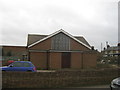
Disused church on Whitehall Road.
This small unknown church is on the junction of Whitehall Road (in front) and Newington Road (on the right). A board outside said that a planning application is being sort for a new housing development on the site.
Image: © David Anstiss
Taken: 6 Feb 2011
0.09 miles