IMAGES TAKEN NEAR TO
Saddlers Mews, RAMSGATE, CT12 5LN
Introduction
This page details the photographs taken nearby to Saddlers Mews, CT12 5LN by members of the Geograph project.
The Geograph project started in 2005 with the aim of publishing, organising and preserving representative images for every square kilometre of Great Britain, Ireland and the Isle of Man.

There are currently over 7.5m images from over14,400 individuals and you can help contribute to the project by visiting https://www.geograph.org.uk
Image Map
Images are licensed for reuse under creativecommons.org/licenses/by-sa/2.0
Notes
- Clicking on the map will re-center to the selected point.
- The higher the marker number, the further away the image location is from the centre of the postcode.
Image Listing (20 Images Found)
Images are licensed for reuse under creativecommons.org/licenses/by-sa/2.0
Image
Details
Distance
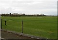
3
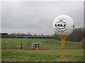
Manston Golf Centre, Driving Range
As seen from the A256 Haine Road.
In the foreground a young man collects all the previous session golf balls in baskets, and put them on his buggy.
Image: © David Anstiss
Taken: 6 Feb 2011
0.13 miles
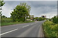
4
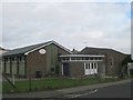
Newington Free Church
On the junction of Quetta Road (on the left) and St.John's Avenue (in front).
Image: © David Anstiss
Taken: 6 Feb 2011
0.13 miles
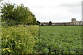
7
Driving range at Manston golf course
Manston is a 9 hole course and driving range http://www.manstongolf.co.uk/
Image: © Nick Smith
Taken: 9 Mar 2008
0.14 miles
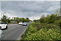
10
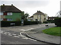
Quetta Road off Stirling Way, Newington
Image: © Nick Smith
Taken: 22 Mar 2008
0.17 miles