IMAGES TAKEN NEAR TO
Jutes Lane, RAMSGATE, CT12 5FH
Introduction
This page details the photographs taken nearby to Jutes Lane, CT12 5FH by members of the Geograph project.
The Geograph project started in 2005 with the aim of publishing, organising and preserving representative images for every square kilometre of Great Britain, Ireland and the Isle of Man.

There are currently over 7.5m images from over14,400 individuals and you can help contribute to the project by visiting https://www.geograph.org.uk
Image Map
Images are licensed for reuse under creativecommons.org/licenses/by-sa/2.0
Notes
- Clicking on the map will re-center to the selected point.
- The higher the marker number, the further away the image location is from the centre of the postcode.
Image Listing (17 Images Found)
Images are licensed for reuse under creativecommons.org/licenses/by-sa/2.0
Image
Details
Distance
3
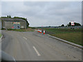
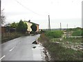
End of the road at Ebbsfleet Farm
This road ends here at the farm and a couple of businesses, part of the East Kent Access phase 2, the new dual carriageway to the A299 is to the right. See https://shareweb.kent.gov.uk/Documents/roads-and-transport/major-transport/east-kent-access-phase-2.pdf
Image: © Nick Smith
Taken: 4 Sep 2011
0.08 miles
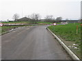
4
Access road to the Weatherlees Hill wastewater treatment works
Image: © Nick Smith
Taken: 4 Sep 2011
0.10 miles
5
Houses on Ebbsfleet Lane
Wasteland and Houses on Ebbsfleet Lane.
Image: © Nick Smith
Taken: 6 Jan 2007
0.13 miles
6
Entrance to sewage works off Ebbsfleet Lane
Image: © Nick Smith
Taken: 12 Jan 2010
0.13 miles
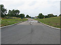
7
View N along Ebbsfleet Lane
From the junction with the road to the sewage works.
Image: © Nick Smith
Taken: 12 Jan 2010
0.13 miles
8
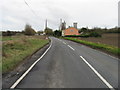
Looking S along Ebbsfleet Lane
The cooling towers of Richborough power station visible behind the house.
Image: © Nick Smith
Taken: 9 Mar 2008
0.14 miles
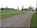
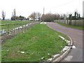
9
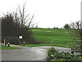
Stonelees Municipal Golf course.
Looking N from car park of Stonelees Golf course.
Image: © Nick Smith
Taken: 6 Jan 2007
0.14 miles
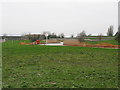
10
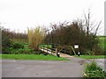
Small bridge over ditch on golf course, Stonelees.
Image: © Nick Smith
Taken: 6 Jan 2007
0.16 miles