IMAGES TAKEN NEAR TO
Ebbsfleet Lane, RAMSGATE, CT12 5DJ
Introduction
This page details the photographs taken nearby to Ebbsfleet Lane, CT12 5DJ by members of the Geograph project.
The Geograph project started in 2005 with the aim of publishing, organising and preserving representative images for every square kilometre of Great Britain, Ireland and the Isle of Man.

There are currently over 7.5m images from over14,400 individuals and you can help contribute to the project by visiting https://www.geograph.org.uk
Image Map
Images are licensed for reuse under creativecommons.org/licenses/by-sa/2.0
Notes
- Clicking on the map will re-center to the selected point.
- The higher the marker number, the further away the image location is from the centre of the postcode.
Image Listing (70 Images Found)
Images are licensed for reuse under creativecommons.org/licenses/by-sa/2.0
Image
Details
Distance
1
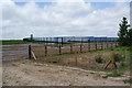
Solar panels near Ebbsfleet Lane
This is a large area of panels on land which was formerly part of Richborough Power Station. It supposedly generates enough energy to power a village.
Image: © Bill Boaden
Taken: 29 Jun 2012
0.06 miles
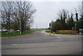
3
View along the A256 at Ebbsfleet turning
The junction was temporarily closed during cable laying work to link the new off-shore wind turbines near Ramsgate.
Image: © Nick Smith
Taken: 5 Apr 2009
0.09 miles
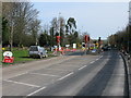
4
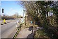
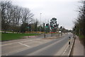
The new traffic lights at the junction of Ebbsfleet Lane with the Ramsgate-Sandwich road
These traffic lights were installed a few weeks ago.
Due to the increased traffic along the main road it was becoming more dangerous to exit Ebbsfleet Lane
Image: © david mills
Taken: 6 May 2007
0.09 miles
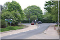
6
Regional Cycle Route 15 heads through Pegwell Bay Nature Reserve
The cyclepath leads away from the A256 Ramsgate Road, through the Nature Reserve on Pegwell Bay towards Cliffs End.
Image: © David Anstiss
Taken: 10 Apr 2011
0.10 miles
7
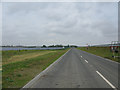
New road through Stonelees
The road serves a few houses and businesses, the new dual carriageway is to the right and slightly higher, see https://shareweb.kent.gov.uk/Documents/roads-and-transport/major-transport/east-kent-access-phase-2.pdf
Image: © Nick Smith
Taken: 4 Sep 2011
0.10 miles
8
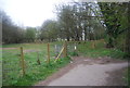
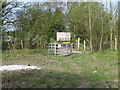
Kissing gate into Pegwell Bay Country Park
Image: © N Chadwick
Taken: 5 Apr 2012
0.10 miles
10
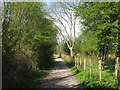
Entrance (or exit) of the Stonelees nature reserve
Image: © Nick Smith
Taken: 5 Apr 2009
0.10 miles