IMAGES TAKEN NEAR TO
Sheriffs Court Lane, RAMSGATE, CT12 4JD
Introduction
This page details the photographs taken nearby to Sheriffs Court Lane, CT12 4JD by members of the Geograph project.
The Geograph project started in 2005 with the aim of publishing, organising and preserving representative images for every square kilometre of Great Britain, Ireland and the Isle of Man.

There are currently over 7.5m images from over14,400 individuals and you can help contribute to the project by visiting https://www.geograph.org.uk
Image Map
Images are licensed for reuse under creativecommons.org/licenses/by-sa/2.0
Notes
- Clicking on the map will re-center to the selected point.
- The higher the marker number, the further away the image location is from the centre of the postcode.
Image Listing (18 Images Found)
Images are licensed for reuse under creativecommons.org/licenses/by-sa/2.0
Image
Details
Distance
1
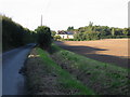
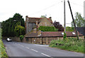
Looking N along Sheriff's Court Lane
The house shown is listed as Bendering on www.planningportal.gov.uk.
Image: © Nick Smith
Taken: 13 Sep 2008
0.01 miles
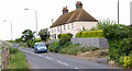
2
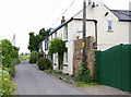
Cottages in Sheriff's Court Lane, Minster,Thanet, Kent
Image: © david mills
Taken: 10 May 2007
0.03 miles
3
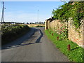
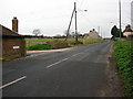
Junction of Sheriff's Court Lane with Monkton Road
Image: © Nick Smith
Taken: 13 Sep 2008
0.09 miles
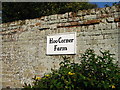
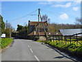
5
Hoo Corner Farm, Minster,Thanet,Kent
Junction of Sheriff's Court Lane on the right.
Image: © david mills
Taken: 10 May 2007
0.09 miles
6
Hoo Corner Farm
On the road from Monkton to Minster.
Image: © Robin Webster
Taken: 20 Mar 2016
0.10 miles
7
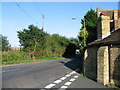
Looking E along Monkton Road
Taken from the junction with Sheriff's Court Lane, Hoo Corner Farm on the corner
Image: © Nick Smith
Taken: 13 Sep 2008
0.10 miles
8
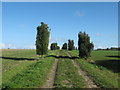
Footpath to Springfield Cottage
This tree lined path leads from Sherriffs Court towards the cottage (below Monkton Road).
Officially, according to the map, the path leads through the field on the right. But most people use the track.
Image: © David Anstiss
Taken: 24 Oct 2010
0.14 miles
9
Monkton Road, Monkton
A view looking west along Monkton Road, with the road to Sheriff's Court on the left hand side.
Image: © David Mastin
Taken: 18 Feb 2007
0.14 miles
10
Cottages on the Minster-Monkton border
Image: © david mills
Taken: 10 May 2007
0.15 miles