IMAGES TAKEN NEAR TO
Acreage Way, CT12 4FG
Introduction
This page details the photographs taken nearby to Acreage Way, CT12 4FG by members of the Geograph project.
The Geograph project started in 2005 with the aim of publishing, organising and preserving representative images for every square kilometre of Great Britain, Ireland and the Isle of Man.

There are currently over 7.5m images from over14,400 individuals and you can help contribute to the project by visiting https://www.geograph.org.uk
Image Map
Images are licensed for reuse under creativecommons.org/licenses/by-sa/2.0
Notes
- Clicking on the map will re-center to the selected point.
- The higher the marker number, the further away the image location is from the centre of the postcode.
Image Listing (35 Images Found)
Images are licensed for reuse under creativecommons.org/licenses/by-sa/2.0
Image
Details
Distance

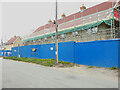
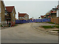
3
Building site, Monkton Street
Planning permission has been granted by Thanet District Council under application number F/TH/21/1795 for “change of use of existing agricultural buildings to light industrial and/or storage use”.
Image: © John Baker
Taken: 2 May 2022
0.05 miles
4
Building site, Monkton Street
Planning permission has been granted by Thanet District Council under application number F/TH/21/1795 for “change of use of existing agricultural buildings to light industrial and/or storage use”.
At the far end of the terrace is the Image
Image: © John Baker
Taken: 18 Sep 2022
0.06 miles
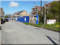
5

Terrace of four houses, Monkton Street
By September 2022, the main structure of this terrace had been constructed on the Image
Image: © John Baker
Taken: 30 Apr 2023
0.06 miles
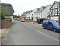
6

Monkton Street
Entrance to Reclamation Yard on right.
Image: © Oast House Archive
Taken: 17 Sep 2010
0.06 miles
7
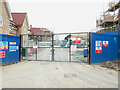
Main entrance to building site, Monkton Street
Planning permission has been granted by Thanet District Council under application number F/TH/21/1795 for “change of use of existing agricultural buildings to light industrial and/or storage use”.
An easterly view of the Image was taken in May 2022.
Image: © John Baker
Taken: 18 Sep 2022
0.06 miles
8
Main entrance to building site, Monkton Street
This was how the Image appeared in September 2022.
Image: © John Baker
Taken: 30 Apr 2023
0.06 miles
9
Monocstune Mews, Monkton Street
This image when Image shows the houses under construction.
Image: © John Baker
Taken: 10 Jun 2018
0.07 miles
10
Looking west-northwest along Monkton Street
Planning permission has been granted by Thanet District Council under application number F/TH/14/0881 for the “re-development of site to include erection of 8 detached three-storey dwellings, with associated parking, and access leading off (of) Monkton Street”. The re-development, at numbers 71-73 in Image, is to be known as Monocstune Mews.
This image of Image shows the re-development after completion.
Image: © John Baker
Taken: 17 Apr 2016
0.07 miles