IMAGES TAKEN NEAR TO
Cornelis Drive, RAMSGATE, CT12 4DZ
Introduction
This page details the photographs taken nearby to Cornelis Drive, CT12 4DZ by members of the Geograph project.
The Geograph project started in 2005 with the aim of publishing, organising and preserving representative images for every square kilometre of Great Britain, Ireland and the Isle of Man.

There are currently over 7.5m images from over14,400 individuals and you can help contribute to the project by visiting https://www.geograph.org.uk
Image Map
Images are licensed for reuse under creativecommons.org/licenses/by-sa/2.0
Notes
- Clicking on the map will re-center to the selected point.
- The higher the marker number, the further away the image location is from the centre of the postcode.
Image Listing (111 Images Found)
Images are licensed for reuse under creativecommons.org/licenses/by-sa/2.0
Image
Details
Distance
1
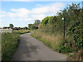
Footpath junction on Watchester Lane
Watchester Lane leads from Minster towards Sherriffs Court.
A footpath follows the lane towards Sherriffs Court Lane. Another footpath leads right towards Thorne Road.
Image: © David Anstiss
Taken: 24 Oct 2010
0.04 miles
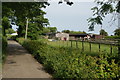
2

Gate to the Scout Camp, Minster
Campsite of the Thanet District Scouts, Marshside. It underwent a £61,000 refurbishment in 2015. It is visited by more than 1,000 young people every year, the majority from Thanet and many from deprived areas in Margate and Ramsgate. Schools and other organisations also use the campsite, giving young people the opportunity to enjoy outdoor activities such as camping, fieldcraft and cooking; encouraging teamwork, building self-confidence and other life skills.
Image: © pam fray
Taken: 12 Aug 2016
0.05 miles
4
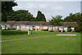
Glebe Court, Minster
Elderly people's housing. The name suggests that it either belongs or once belonged to the Church of England.
Image: © Bill Boaden
Taken: 28 Jun 2012
0.10 miles
5
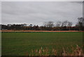
Minster across a field off Marsh Farm Rd
Image: © N Chadwick
Taken: 12 Dec 2009
0.14 miles
6
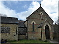
St. Mildred's church and presbytery, Minster-in-Thanet
Situated in St. Mildred's Road. The church has been closed for some time and permission to demolish it and build houses on the site was denied in 2010. The site is now being cleared. It has also been necessary to clear Japanese knotweed from the grounds.
Image: © pam fray
Taken: 27 Mar 2016
0.17 miles
7
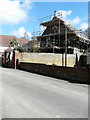
Conversion of St Mildred?s Church, 7, St Mildred?s Road
Planning permission has been granted by Thanet District Council under application number F/TH/11/1071 for the “change of use and conversion of church to single dwelling, erection of first floor side extension, external alterations and creation of associated parking”.
This image shows Image after it had been converted.
Image: © John Baker
Taken: 17 Apr 2016
0.18 miles
8

St Mildred?s Church, 7, St Mildred?s Road
This image shows the Image
Image: © John Baker
Taken: 10 Jun 2018
0.18 miles
9

Wildlife in a garden in Minster-in-Thanet
Common frog, Rana temporaria, of which there are dozens in this wildlife-friendly garden in Station Road, Minster.
Image: © pam fray
Taken: 20 Jul 2016
0.18 miles
10

Closed church
On St. Mildred's Road.
Image: © David Anstiss
Taken: 24 Oct 2010
0.18 miles