IMAGES TAKEN NEAR TO
Fairfield Road, RAMSGATE, CT12 4AW
Introduction
This page details the photographs taken nearby to Fairfield Road, CT12 4AW by members of the Geograph project.
The Geograph project started in 2005 with the aim of publishing, organising and preserving representative images for every square kilometre of Great Britain, Ireland and the Isle of Man.

There are currently over 7.5m images from over14,400 individuals and you can help contribute to the project by visiting https://www.geograph.org.uk
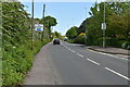
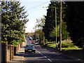
Image Map
Images are licensed for reuse under creativecommons.org/licenses/by-sa/2.0
Notes
- Clicking on the map will re-center to the selected point.
- The higher the marker number, the further away the image location is from the centre of the postcode.
Image Listing (58 Images Found)
Images are licensed for reuse under creativecommons.org/licenses/by-sa/2.0
Image
Details
Distance
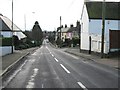
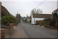
7
Tothill Street, Minster, Thanet, Kent
A view looking North towards the Hill House estate which is in the distance on the right.
The entrance to Orchard Close is on the left, just about level with the red car
Image: © david mills
Taken: 22 Apr 2007
0.08 miles
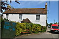

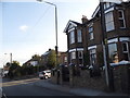
10
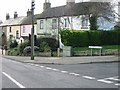
Row of cottages at the junction of Orchard Close and Tothill Street, Minster.
Image: © Nick Smith
Taken: 13 Jan 2007
0.09 miles