IMAGES TAKEN NEAR TO
Connors Way, CT1 1WB
Introduction
This page details the photographs taken nearby to Connors Way, CT1 1WB by members of the Geograph project.
The Geograph project started in 2005 with the aim of publishing, organising and preserving representative images for every square kilometre of Great Britain, Ireland and the Isle of Man.

There are currently over 7.5m images from over14,400 individuals and you can help contribute to the project by visiting https://www.geograph.org.uk
Image Map (Loading...)


Getting Data...Please wait
Leaflet Map data © OpenStreetMap
Images are licensed for reuse under creativecommons.org/licenses/by-sa/2.0
Notes
- Clicking on the map will re-center to the selected point.
- The higher the marker number, the further away the image location is from the centre of the postcode.
Image Listing (56 Images Found)
Images are licensed for reuse under creativecommons.org/licenses/by-sa/2.0
Image
Details
Distance
1
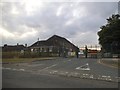
Empty barracks on St Martin's Hill
This was the Argyll and Sutherland Highlanders 5th Battalion
Image: © David Howard
Taken: 22 Jun 2017
0.02 miles
2
Buffs Road
The road was the Image and the development is presumably linked to the Royal Parade at Image to the east of this location.
Image: © John Baker
Taken: 28 Aug 2022
0.04 miles
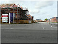
3
Site of Howe Barracks, Littlebourne Road
Planning permission has been granted by Canterbury City Council under application number CA//14/01230 for a hybrid planning application comprising:
1) application for outline planning permission for the demolition of all but three of the Barracks' buildings and the redevelopment of the site for up to 500 dwellings with new formal and informal public spaces and landscaping together with revised access from Littlebourne Road, new parking to Littlebourne Road and a road link connecting Littlebourne Road with Chaucer Road/Military Road.
2) application to change the use of the retained buildings (Gymnasium, Chapel and Small Arms Trainer) to community uses (Use Classes D1 and D2). The application is accompanied by an Environmental Statement submitted pursuant to the Town and Country Planning (Environmental Impact Assessment).
The development is to be known as Royal Parade.
This image of Image shows the former buildings.
Image: © John Baker
Taken: 18 Feb 2018
0.04 miles
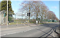
4
Former entrance to Howe Barracks, Littlebourne Road
Planning permission has been granted by Canterbury City Council under application number CA//14/01230 for a hybrid planning application comprising:
1) application for outline planning permission for the demolition of all but three of the Barracks' buildings and the redevelopment of the site for up to 500 dwellings with new formal and informal public spaces and landscaping together with revised access from Littlebourne Road, new parking to Littlebourne Road and a road link connecting Littlebourne Road with Chaucer Road/Military Road.
2) application to change the use of the retained buildings (Gymnasium, Chapel and Small Arms Trainer) to community uses (Use Classes D1 and D2). The application is accompanied by an Environmental Statement submitted pursuant to the Town and Country Planning (Environmental Impact Assessment).
The development is to be known as Royal Parade.
This image shows the Image where now there are no traces of the barracks.
Image: © John Baker
Taken: 18 Feb 2018
0.04 miles
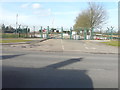
5

The old entrance to Littlebourne Barracks, Canterbury
They have now been demolished and is being replaced by a housing estate.
Image: © David Howard
Taken: 21 Mar 2020
0.04 miles
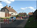
6
Buffs Road
In the distance, beyond the parked lorry, is Image
Image: © John Baker
Taken: 23 Jul 2023
0.04 miles
8
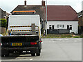
9, Littlebourne Road
Viewed from Buffs Road, the fire-damaged roof has been rebuilt. This view of Image shows the house during its reconstruction.
Image: © John Baker
Taken: 23 Jul 2023
0.05 miles
9
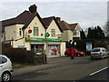
Local shop on the outskirts of Canterbury
Image: © Nick Smith
Taken: 31 Dec 2007
0.05 miles
10
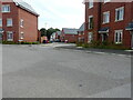
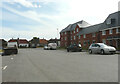
Connors Way
It forms a junction with Buffs Road on a development named Grand Parade.
Image: © John Baker
Taken: 23 Jul 2023
0.05 miles