IMAGES TAKEN NEAR TO
New Ruttington Lane, CANTERBURY, CT1 1UB
Introduction
This page details the photographs taken nearby to New Ruttington Lane, CT1 1UB by members of the Geograph project.
The Geograph project started in 2005 with the aim of publishing, organising and preserving representative images for every square kilometre of Great Britain, Ireland and the Isle of Man.

There are currently over 7.5m images from over14,400 individuals and you can help contribute to the project by visiting https://www.geograph.org.uk
Image Map
Images are licensed for reuse under creativecommons.org/licenses/by-sa/2.0
Notes
- Clicking on the map will re-center to the selected point.
- The higher the marker number, the further away the image location is from the centre of the postcode.
Image Listing (343 Images Found)
Images are licensed for reuse under creativecommons.org/licenses/by-sa/2.0
Image
Details
Distance
1
Roundabout on Tourtel Road, Canterbury
Image: © David Howard
Taken: 31 Jul 2016
0.05 miles
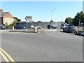
2
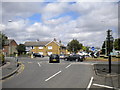
Northgate roundabout, Canterbury
The roundabout where Northgate (foreground) meets the A28.
Image: © Richard Vince
Taken: 25 Aug 2012
0.05 miles
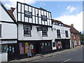
3
![Canterbury houses [194]](https://s0.geograph.org.uk/geophotos/07/10/08/7100892_dce7074c_120x120.jpg)
Canterbury houses [194]
Originally two houses, now one, numbers 28 and 29 Northgate were built in the 18th century. Constructed in two parallel ranges, in stuccoed brick under a tile roof. Listed, for group value, grade II with details at: https://historicengland.org.uk/listing/the-list/list-entry/1260708
Canterbury is a small historic city on the River Stour in Kent, some 54 miles southeast of London. Occupied since prehistoric times, it became an important Roman city. In 672, the see of Canterbury gained authority over the entire English Church. After the murder of Archbishop Thomas Becket at the cathedral in 1170, pilgrims from all parts of Christendom came to visit his shrine until the Dissolution. Today, Canterbury is a popular tourist destination and one of the most-visited cities in the United Kingdom. The city has a substantial student population, with four university campuses.
Image: © Michael Dibb
Taken: 12 Sep 2021
0.06 miles
4
![Canterbury buildings [161]](https://s3.geograph.org.uk/geophotos/07/10/22/7102291_2b2383fa_120x120.jpg)
Canterbury buildings [161]
Number 114A Northgate is a 16th or 17th century building. Timber framed, stuccoed, under a tile roof with an early 19th century shopfront. Listed, grade II, with details at: https://historicengland.org.uk/listing/the-list/list-entry/1260676
Canterbury is a small historic city on the River Stour in Kent, some 54 miles southeast of London. Occupied since prehistoric times, it became an important Roman city. In 672, the see of Canterbury gained authority over the entire English Church. After the murder of Archbishop Thomas Becket at the cathedral in 1170, pilgrims from all parts of Christendom came to visit his shrine until the Dissolution. Today, Canterbury is a popular tourist destination and one of the most-visited cities in the United Kingdom. The city has a substantial student population, with four university campuses.
Image: © Michael Dibb
Taken: 12 Sep 2021
0.06 miles
5
Hoarding, Sturry Road
Possibly erected to stop squatters taking up residence on the derelict site known as Cold Harbour, whose buildings formed a group of council flats and bedsits.
This image of Image shows the site before the hoarding was erected.
Snow, which has fallen courtesy of “the beast from the east”, lay here around a depth of 4” (10 cm).
Image: © John Baker
Taken: 28 Feb 2018
0.06 miles
6
![Canterbury buildings [131]](https://s1.geograph.org.uk/geophotos/07/10/08/7100897_0ab18559_120x120.jpg)
Canterbury buildings [131]
Number 30 Northgate has been opened out and is now effectively part of The Penny Theatre, number 31 Northgate Image It is a 16th or 17th century building refronted in the 18th century. Timber framed and plastered under a tile roof. Behind the shop, in a back room, is a miniature Regency theatre with a very narrow gallery on three sides of the room built on very slender columns. Listed, grade II*, with details at: https://historicengland.org.uk/listing/the-list/list-entry/1096944
Canterbury is a small historic city on the River Stour in Kent, some 54 miles southeast of London. Occupied since prehistoric times, it became an important Roman city. In 672, the see of Canterbury gained authority over the entire English Church. After the murder of Archbishop Thomas Becket at the cathedral in 1170, pilgrims from all parts of Christendom came to visit his shrine until the Dissolution. Today, Canterbury is a popular tourist destination and one of the most-visited cities in the United Kingdom. The city has a substantial student population, with four university campuses.
Image: © Michael Dibb
Taken: 12 Sep 2021
0.06 miles
7
![Canterbury houses [196]](https://s2.geograph.org.uk/geophotos/07/10/16/7101698_da44f498_120x120.jpg)
Canterbury houses [196]
Numbers 113 and 114 Northgate are a pair of 16th century houses. Timber framed, plastered, jettied to the street, the ground floor rebuilt in brick, all under a tile roof. Listed, grade II, with details at: https://historicengland.org.uk/listing/the-list/list-entry/1241116
Canterbury is a small historic city on the River Stour in Kent, some 54 miles southeast of London. Occupied since prehistoric times, it became an important Roman city. In 672, the see of Canterbury gained authority over the entire English Church. After the murder of Archbishop Thomas Becket at the cathedral in 1170, pilgrims from all parts of Christendom came to visit his shrine until the Dissolution. Today, Canterbury is a popular tourist destination and one of the most-visited cities in the United Kingdom. The city has a substantial student population, with four university campuses.
Image: © Michael Dibb
Taken: 12 Sep 2021
0.06 miles
8
Development site, Sturry Road
Planning permission has been granted by Canterbury City Council under application number CA//17/02092 for a “proposed multiplex cinema, 8 single-storey bar/restaurant units, five-storey building comprising 3 retail units with student accommodation (111 bed) above, 1 part four, part six-storey building for purpose built student accommodation (382 bed), 1 five-storey building comprising 54 flats, 1 three-storey building comprising 17 flats, 16 two-storey dwellings, 1 three, four and five -storey building comprising 102 flats with associated public realm, access alterations, car parking, riverside walkway and 'launch' with canoe store (following demolition of existing buildings).
This was a view of the Image in February 2018, which partly hid the former buildings.
Image: © John Baker
Taken: 25 Aug 2019
0.06 miles
9
Former Dairy Crest depot, 57-61, Military Road
Canterbury City Council is considering whether or not to grant planning permission under application number CA//17/00648 for a “proposed two-storey building with accommodation in the roof space and three-storey building with basement comprising of 194 student rooms and associated facilities; amenity space; parking; access and areas of landscaping following demolition of existing buildings and structures”.
This is the back of the former depot from Notley Street (likewise this image of the Image) and this the view of the Image was taken from the front.
Image: © John Baker
Taken: 21 May 2017
0.07 miles