IMAGES TAKEN NEAR TO
Laxton Way, CANTERBURY, CT1 1FT
Introduction
This page details the photographs taken nearby to Laxton Way, CT1 1FT by members of the Geograph project.
The Geograph project started in 2005 with the aim of publishing, organising and preserving representative images for every square kilometre of Great Britain, Ireland and the Isle of Man.

There are currently over 7.5m images from over14,400 individuals and you can help contribute to the project by visiting https://www.geograph.org.uk
Image Map
Images are licensed for reuse under creativecommons.org/licenses/by-sa/2.0
Notes
- Clicking on the map will re-center to the selected point.
- The higher the marker number, the further away the image location is from the centre of the postcode.
Image Listing (33 Images Found)
Images are licensed for reuse under creativecommons.org/licenses/by-sa/2.0
Image
Details
Distance
1
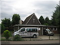
Active Life Ltd
Modern age church on Sussex Avenue.
Image: © David Anstiss
Taken: 15 Aug 2010
0.12 miles
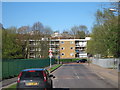
2
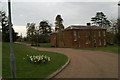
The Asylum's taken over the lunatics
Canterbury's former Psychiatric Hospital is now Health Service Offices
Image: © David Long
Taken: 20 Apr 2006
0.17 miles
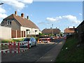
4
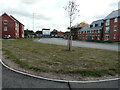
Buffs Road
The development has been named Royal Parade.
The house covered in plastic sheeting is number 9 Littlebourne Road for which planning permission has been approved by Canterbury City Council under application numbers CA/22/00548 for “a two storey and single-storey rear extension” and CA/22/00289 to “rebuild fire damaged roof, first floor rear extension, roof lights to rear, and removal of chimney”.
Image: © John Baker
Taken: 28 Aug 2022
0.18 miles
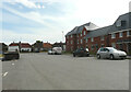
5
9, Littlebourne Road
Viewed from Buffs Road, the fire-damaged roof has been rebuilt. This view of Image shows the house during its reconstruction.
Image: © John Baker
Taken: 23 Jul 2023
0.18 miles
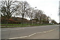
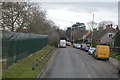
6
Pilgrims Road
Approaching junction with Spring Lane.
Image: © Oast House Archive
Taken: 8 Apr 2011
0.18 miles
7
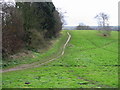
Unofficial footpath on St Martin's Hill
This area of grassland lies between the A257 St Martin's Hill and Spring Lane. No footpath is marked on the map but it is clearly well used.
Image: © Nick Smith
Taken: 31 Dec 2007
0.19 miles
10
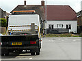
Buffs Road
In the distance, beyond the parked lorry, is Image
Image: © John Baker
Taken: 23 Jul 2023
0.20 miles