IMAGES TAKEN NEAR TO
Elliot Close, CANTERBURY, CT1 1FS
Introduction
This page details the photographs taken nearby to Elliot Close, CT1 1FS by members of the Geograph project.
The Geograph project started in 2005 with the aim of publishing, organising and preserving representative images for every square kilometre of Great Britain, Ireland and the Isle of Man.

There are currently over 7.5m images from over14,400 individuals and you can help contribute to the project by visiting https://www.geograph.org.uk
Image Map
Images are licensed for reuse under creativecommons.org/licenses/by-sa/2.0
Notes
- Clicking on the map will re-center to the selected point.
- The higher the marker number, the further away the image location is from the centre of the postcode.
Image Listing (30 Images Found)
Images are licensed for reuse under creativecommons.org/licenses/by-sa/2.0
Image
Details
Distance
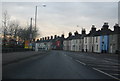
1
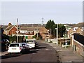
Reed Avenue, Canterbury
Taken at the corner of Tennyson Avenue facing the junction of Reed Avenue and Field Avenue farther down the hill. The area is known variously as Poets Estate and Northgate Ward.
Image: © David Kemp
Taken: 14 Jan 2007
0.09 miles
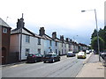
2
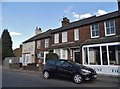
Houses and shop on Sturry Road, Canterbury
Image: © David Howard
Taken: 31 Jul 2016
0.09 miles
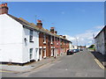
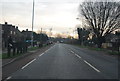
7
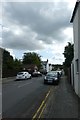
South Street
Looking along South Street from Sturry Road.
Image: © DS Pugh
Taken: 20 Aug 2019
0.12 miles
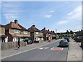
8
Along South Street
Looking along South Street from the junction with Old Park Avenue.
Image: © DS Pugh
Taken: 20 Aug 2019
0.12 miles
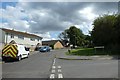
10
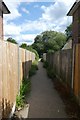
Footpath from Dickens Avenue
Looking along a footpath leading towards Parkside primary school.
Image: © DS Pugh
Taken: 20 Aug 2019
0.13 miles