IMAGES TAKEN NEAR TO
St. Radigunds Place, CANTERBURY, CT1 1AF
Introduction
This page details the photographs taken nearby to St. Radigunds Place, CT1 1AF by members of the Geograph project.
The Geograph project started in 2005 with the aim of publishing, organising and preserving representative images for every square kilometre of Great Britain, Ireland and the Isle of Man.

There are currently over 7.5m images from over14,400 individuals and you can help contribute to the project by visiting https://www.geograph.org.uk
Image Map
Images are licensed for reuse under creativecommons.org/licenses/by-sa/2.0
Notes
- Clicking on the map will re-center to the selected point.
- The higher the marker number, the further away the image location is from the centre of the postcode.
Image Listing (1331 Images Found)
Images are licensed for reuse under creativecommons.org/licenses/by-sa/2.0
Image
Details
Distance
1
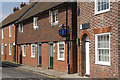
Duck Lane, Canterbury
Attractive terraced houses seen from the junction with St Radigund's Street.
Image: © Stephen McKay
Taken: 24 May 2008
0.01 miles
2
![Canterbury houses [159]](https://s2.geograph.org.uk/geophotos/07/09/98/7099854_d30e55a4_120x120.jpg)
Canterbury houses [159]
Number 1 Duck Lane was built in the early 19th century. Constructed of stuccoed brick under a slate roof. Listed, grade II, with details at: https://historicengland.org.uk/listing/the-list/list-entry/1240573
Canterbury is a small historic city on the River Stour in Kent, some 54 miles southeast of London. Occupied since prehistoric times, it became an important Roman city. In 672, the see of Canterbury gained authority over the entire English Church. After the murder of Archbishop Thomas Becket at the cathedral in 1170, pilgrims from all parts of Christendom came to visit his shrine until the Dissolution. Today, Canterbury is a popular tourist destination and one of the most-visited cities in the United Kingdom. The city has a substantial student population, with four university campuses.
Image: © Michael Dibb
Taken: 10 Sep 2021
0.02 miles
3
![Canterbury houses [161]](https://s0.geograph.org.uk/geophotos/07/09/98/7099856_d8d167d2_120x120.jpg)
Canterbury houses [161]
Numbers 3 and 4 Duck Lane are a pair of early 19yh century houses. Constructed of red brick, number 4 painted, under a slate roof. Listed, grade II, with details at: https://historicengland.org.uk/listing/the-list/list-entry/1240574
Canterbury is a small historic city on the River Stour in Kent, some 54 miles southeast of London. Occupied since prehistoric times, it became an important Roman city. In 672, the see of Canterbury gained authority over the entire English Church. After the murder of Archbishop Thomas Becket at the cathedral in 1170, pilgrims from all parts of Christendom came to visit his shrine until the Dissolution. Today, Canterbury is a popular tourist destination and one of the most-visited cities in the United Kingdom. The city has a substantial student population, with four university campuses.
Image: © Michael Dibb
Taken: 13 Sep 2021
0.02 miles
4
![Canterbury houses [162]](https://s1.geograph.org.uk/geophotos/07/09/98/7099857_886decdc_120x120.jpg)
Canterbury houses [162]
Numbers 5 and 6 Duck Lane are a pair of late 18th century houses. Constructed of red brick under an old tile roof. Listed, grade II, with details at: https://historicengland.org.uk/listing/the-list/list-entry/1336819
Canterbury is a small historic city on the River Stour in Kent, some 54 miles southeast of London. Occupied since prehistoric times, it became an important Roman city. In 672, the see of Canterbury gained authority over the entire English Church. After the murder of Archbishop Thomas Becket at the cathedral in 1170, pilgrims from all parts of Christendom came to visit his shrine until the Dissolution. Today, Canterbury is a popular tourist destination and one of the most-visited cities in the United Kingdom. The city has a substantial student population, with four university campuses.
Image: © Michael Dibb
Taken: 10 Sep 2021
0.02 miles
5
![Canterbury houses [160]](https://s3.geograph.org.uk/geophotos/07/09/98/7099855_f4eb64b2_120x120.jpg)
Canterbury houses [160]
The Little House, number 2 Duck Lane, seen here on the right, was built in the early 19th century. Constructed of stuccoed brick under a slate roof. Listed, grade II, with details at: https://historicengland.org.uk/listing/the-list/list-entry/1085055
Number 2A Duck lane, seen here on the left, was originally an early 19th century industrial building, now converted into a residence. Weatherboarded under a slate roof. Listed, grade II, with details at: https://historicengland.org.uk/listing/the-list/list-entry/1085056
Canterbury is a small historic city on the River Stour in Kent, some 54 miles southeast of London. Occupied since prehistoric times, it became an important Roman city. In 672, the see of Canterbury gained authority over the entire English Church. After the murder of Archbishop Thomas Becket at the cathedral in 1170, pilgrims from all parts of Christendom came to visit his shrine until the Dissolution. Today, Canterbury is a popular tourist destination and one of the most-visited cities in the United Kingdom. The city has a substantial student population, with four university campuses.
Image: © Michael Dibb
Taken: 13 Sep 2021
0.02 miles
6
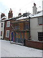
2a, Duck Lane
Planning permission was granted by Canterbury City Council under application number CA//16/02014 for a “proposed change of use of workshop to dwelling with second floor extension, alterations to front and rear elevations with dormers to front and rear”.
Snow, which has fallen courtesy of “the beast from the east”, lay here around a depth of 4” (10 cm).
Image: © John Baker
Taken: 28 Feb 2018
0.03 miles
8
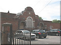
Derelict building off St John's Place
The building is in the grounds of Kingsmead School (the photo was taken from the entrance to the school car park) and bears a date stone 1900, but its original function was not apparent.
Image: © Stephen Craven
Taken: 17 Jun 2010
0.03 miles
9
16, St Radigunds Street
Planning permission has been granted by Canterbury City Council under application numbers CA//16/00641 and CA//16/00642 for the “restoration of street frontage building and change of use to education. Demolition of existing workshop store building, erection of replacement two storey building as use for Kings School day house. Change of use of land to the rear of Hawkswells to education/residential amenity space. Demolition of garden room addition at 1 Duck Lane, replacement structure and creation of new opening”.
Application number CA//16/00642 refers to granting listed building consent as it a grade II listed 18th century industrial building, described as having two weather-boarded storeys and a brick ground floor http://www.britishlistedbuildings.co.uk/101357524-16-st-radigund-street-canterbury#.WTrn-v6GPcc
Image: © John Baker
Taken: 21 May 2017
0.03 miles
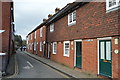
10
15 & 16, St Radigunds Street
Planning permission has been granted by Canterbury City Council under application numbers CA//16/00641 and CA//16/00642 for the “restoration of street frontage building and change of use to education. Demolition of existing workshop store building, erection of replacement two storey building as use for Kings School day house. Change of use of land to the rear of Hawkswells to education/residential amenity space. Demolition of garden room addition at 1 Duck Lane, replacement structure and creation of new opening”. These applications refer to Image
Application number CA//16/00642 refers to granting listed building consent as it a grade II listed 18th century industrial building, described as having two weather-boarded storeys and a brick ground floor https://www.britishlistedbuildings.co.uk/101357524-16-st-radigund-street-canterbury#.WTrn-v6GPcc
Hawkswells (number 15) appears to be having work carried out to its roof.
Image: © John Baker
Taken: 3 Dec 2017
0.03 miles