IMAGES TAKEN NEAR TO
Marlborough Road, RAMSGATE, CT11 9BU
Introduction
This page details the photographs taken nearby to Marlborough Road, CT11 9BU by members of the Geograph project.
The Geograph project started in 2005 with the aim of publishing, organising and preserving representative images for every square kilometre of Great Britain, Ireland and the Isle of Man.

There are currently over 7.5m images from over14,400 individuals and you can help contribute to the project by visiting https://www.geograph.org.uk
Image Map
Images are licensed for reuse under creativecommons.org/licenses/by-sa/2.0
Notes
- Clicking on the map will re-center to the selected point.
- The higher the marker number, the further away the image location is from the centre of the postcode.
Image Listing (176 Images Found)
Images are licensed for reuse under creativecommons.org/licenses/by-sa/2.0
Image
Details
Distance
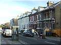
5
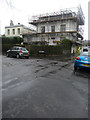
Royal Villa, 13, Vale Square
Planning permission was granted by Thanet District Council under application number L/TH/17/1183 for an “application for listed building consent for replacement of roof”.
Image: © John Baker
Taken: 31 Dec 2017
0.05 miles
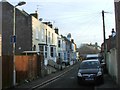
10
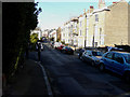
Looking north-northwest along Vale Square
On the right, number 4 has had scaffolding erected on its frontage.
Image: © John Baker
Taken: 16 Feb 2016
0.07 miles