IMAGES TAKEN NEAR TO
Turner Street, RAMSGATE, CT11 8NL
Introduction
This page details the photographs taken nearby to Turner Street, CT11 8NL by members of the Geograph project.
The Geograph project started in 2005 with the aim of publishing, organising and preserving representative images for every square kilometre of Great Britain, Ireland and the Isle of Man.

There are currently over 7.5m images from over14,400 individuals and you can help contribute to the project by visiting https://www.geograph.org.uk
Image Map (Loading...)


Getting Data...Please wait
Leaflet Map data © OpenStreetMap
Images are licensed for reuse under creativecommons.org/licenses/by-sa/2.0
Notes
- Clicking on the map will re-center to the selected point.
- The higher the marker number, the further away the image location is from the centre of the postcode.
Image Listing (462 Images Found)
Images are licensed for reuse under creativecommons.org/licenses/by-sa/2.0
Image
Details
Distance
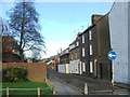
1

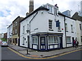
Converted chapel, Ramsgate
On Turner Street. Now converted into 3 flats/houses.
Image: © David Anstiss
Taken: 8 May 2011
0.02 miles
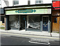
2

Smyrna, 62, King Street
The advertisements in the window appear barely readable than when Image was photographed in December 2017.
Image: © John Baker
Taken: 18 Apr 2021
0.03 miles
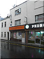
4
Ruenthai, 66, King Street
This oriental grocer appears to be permanently closed.
Image: © John Baker
Taken: 18 Apr 2021
0.03 miles
5

Fire-damaged house, King Street
Seen from the Plains of Waterloo, the ground floor door and window of number 82 is boarded up and the wall above the door indicates that the house has been internally damaged by fire.
Image: © John Baker
Taken: 19 Nov 2013
0.03 miles
6
Smyrna, 62, King Street
The signage indicates that the business specialized in patisserie and desserts as well as being a café bar.
Image: © John Baker
Taken: 31 Dec 2017
0.04 miles
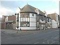
7
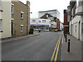
Looking south along King Street
Towards the building clad in scaffolding and plastic sheeting. Planning permission has been granted by Thanet District Council under application number F/TH/14/0660 for a “change of use from retail to three 3-bed flats, nine 2-bed flats and one 1-bed flat, together with erection of second floor and roof extension, insertion of six dormer windows to front elevation and one dormer window to rear elevation, installation of balconies to rear elevation and replacement of shop front with residential frontage”. The building is numbered 69-73 and it was formerly a discount store stocking carpets, rugs, vinyls and underlays.
Image: © John Baker
Taken: 15 Sep 2015
0.04 miles
9
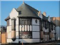
Braces, King Street
Closed pub at the junction Belmont Street.
Image: © Oast House Archive
Taken: 16 Oct 2011
0.04 miles
10
The former Braces public house, 98 King Street
It has also been known as Swiss Cottage, Duke’s and the Duke of Kent http://www.dover-kent.com/Pubs/Braces-Ramsgate.html
Image: © John Baker
Taken: 19 Nov 2013
0.04 miles