IMAGES TAKEN NEAR TO
Beach Drive, CT11 8HF
Introduction
This page details the photographs taken nearby to Beach Drive, CT11 8HF by members of the Geograph project.
The Geograph project started in 2005 with the aim of publishing, organising and preserving representative images for every square kilometre of Great Britain, Ireland and the Isle of Man.

There are currently over 7.5m images from over14,400 individuals and you can help contribute to the project by visiting https://www.geograph.org.uk
Image Map
Images are licensed for reuse under creativecommons.org/licenses/by-sa/2.0
Notes
- Clicking on the map will re-center to the selected point.
- The higher the marker number, the further away the image location is from the centre of the postcode.
Image Listing (579 Images Found)
Images are licensed for reuse under creativecommons.org/licenses/by-sa/2.0
Image
Details
Distance
1
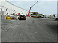
Development site, Marina Esplanade
Planning permission has been granted by Thanet District Council under application number F/TH/03/1200 for the “redevelopment of the site, up to 5 storeys in height, for 107 residential apartments comprising 1, 2 and 3 bed units and penthouses, a 60-bed hotel with conference and function facilities, (3,581 sq metres), and health and fitness centre (97 sq metres), retail or food/drink (1,810 sq metres), a children's play area (244 sq metres) and 204 ancillary parking spaces, together with external staircase access to Wellington Crescent and means of access from Harbour Parade and Marina Esplanade including the stopping up of Marina Esplanade with the relocation of the roundabout further east, and the reconfiguring of the western open area”.
The development is being built on the Image
Image: © John Baker
Taken: 18 Apr 2021
0.00 miles
2
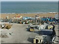
Builder's compound, Ramsgate sands
View from Madeira Walk. It is part of the final stage of development of new apartment blocks on the former Ramsgate Harbour railway station site.
Image: © Alan Murray-Rust
Taken: 3 Sep 2022
0.01 miles
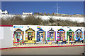
3
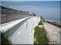
The Great Wall of Ramsgate
http://www.spanglefish.com/GreatWallofRamsgate/index.asp?pageid=231064
Image: © Chris McAuley
Taken: 12 Dec 2011
0.01 miles
5

Picture of Richborough Power Station
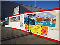
This picture of the former Richborough Power Station is one of many decorating hoardings in front of a development which has come to a standstill. The three cooling towers of Richborough Power Station Image] which were demolitished in March 2012
Image: © Philip Halling
Taken: 16 Sep 2012
0.02 miles
6
The Great Wall of Ramsgate
The entrance to the construction site and the start of The Great Wall of Ramsgate.
http://www.spanglefish.com/GreatWallofRamsgate/index.asp?pageid=231064
Image: © Chris McAuley
Taken: 12 Dec 2011
0.02 miles
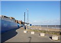
9
Funfair, Ramsgate
It was located on the further side of a roundabout at the end of Harbour Parade.
Image: © John Baker
Taken: 19 Aug 2018
0.02 miles
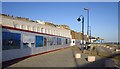
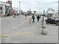
10
Hoarding, Harbour Parade
The hoarding has a gate that allows entry to the Royal Sands development beyond. This was the case last September when the open gate showed Image Now the work has been completed, this view shows the protective coating that was applied to stabilize the cliff façade, after remedial work had taken place.
Image: © John Baker
Taken: 16 Feb 2016
0.03 miles