IMAGES TAKEN NEAR TO
Station Approach Road, RAMSGATE, CT11 7RN
Introduction
This page details the photographs taken nearby to Station Approach Road, CT11 7RN by members of the Geograph project.
The Geograph project started in 2005 with the aim of publishing, organising and preserving representative images for every square kilometre of Great Britain, Ireland and the Isle of Man.

There are currently over 7.5m images from over14,400 individuals and you can help contribute to the project by visiting https://www.geograph.org.uk
Image Map
Images are licensed for reuse under creativecommons.org/licenses/by-sa/2.0
Notes
- Clicking on the map will re-center to the selected point.
- The higher the marker number, the further away the image location is from the centre of the postcode.
Image Listing (118 Images Found)
Images are licensed for reuse under creativecommons.org/licenses/by-sa/2.0
Image
Details
Distance
2
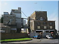
The (former) Rank Hovis Flour Mill, Margate Road, CT11
Image: © Mike Quinn
Taken: 23 Apr 2013
0.04 miles
3
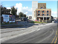
Conversion of former Rank-Hovis flour mill, Margate Road
This view of Image shows it to be in a derelict state. Planning permission has been granted by Thanet District Council under application number F/TH/14/0994 for the “change of use and extension of existing building, erection of two buildings of 3 to 10 storeys and 3 to 6 storeys in height to provide 72 apartments and erection of 17 dwelling houses, following demolition of existing grain silos, wheat feed and machinery buildings, alterations to existing access onto Margate Road and associated parking, land excavation and landscaping without compliance with conditions 2, 6, 10, 11, 16, 19, 20, 21, 27 of planning permission F/TH/11/0288 to allow double glazed steel windows in main mill building, alterations to external design and material including of lift tower extensions, alterations to internal layout and alterations to vehicular access from Margate Road, and amendments to the phasing plan. The council describes the building as Isle Of Thanet Flour Mills.
Following its conversion, the building was named Image
Image: © John Baker
Taken: 16 Feb 2016
0.04 miles
4
Kairos Church, Anath Gospel Hall, Ramsgate
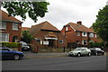
The OS large scale maps show that this small church was built in the 1930s. The building was once used by the Open Brotherhood. It is now used by Kairos Church, the Thanet international community church.
Image: © Christine Johnstone
Taken: 17 Feb 2022
0.05 miles
5
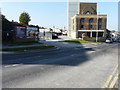
The Bread Factory, Margate Road
The Image appears to have been completed and the conversion has been given a name. Further development seems to be ongoing, to the left and at the far end of the carpark.
Image: © John Baker
Taken: 23 Oct 2016
0.05 miles
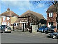
7
Anath Gospel Hall
A very small church tucked among the houses on Station Approach Road.
Image: © Bill Boaden
Taken: 29 Jun 2012
0.05 miles
8
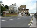
Former Rank-Hovis flour mill, Margate Road
Grade II listed building built in 1865 from plans by Edward Welby Pugin, with 3rd and 4th storeys added in late 19th or early 20th century http://www.britishlistedbuildings.co.uk/en-171887-rank-hovis-flour-mills-ramsgate-kent
Image: © John Baker
Taken: 28 Jul 2013
0.05 miles