IMAGES TAKEN NEAR TO
Helvellyn Avenue, RAMSGATE, CT11 0RW
Introduction
This page details the photographs taken nearby to Helvellyn Avenue, CT11 0RW by members of the Geograph project.
The Geograph project started in 2005 with the aim of publishing, organising and preserving representative images for every square kilometre of Great Britain, Ireland and the Isle of Man.

There are currently over 7.5m images from over14,400 individuals and you can help contribute to the project by visiting https://www.geograph.org.uk
Image Map
Images are licensed for reuse under creativecommons.org/licenses/by-sa/2.0
Notes
- Clicking on the map will re-center to the selected point.
- The higher the marker number, the further away the image location is from the centre of the postcode.
Image Listing (46 Images Found)
Images are licensed for reuse under creativecommons.org/licenses/by-sa/2.0
Image
Details
Distance
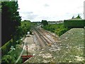
2

Railway west of Ramsgate station
The station and depot are beyond the next bridge, but closer is the train washer, on the left.
Image: © Robin Webster
Taken: 29 Nov 2016
0.11 miles
5
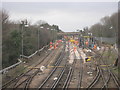
Army of orange men on the railway lines in Ramsgate
As seen from the B2014 Newington Road. Looking along the line from Ramsgate towards Minster.
This Sunday, the line between Minster and Margate is closed and undergoing 'essential' railway maintenance works.
In the background is the Manston Road bridge.
Image: © David Anstiss
Taken: 6 Feb 2011
0.16 miles
8
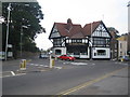
Ramsgate: The Wheatsheaf Public House, St Lawrence
At the junction of the A255 High Street St Lawrence with the B2050 Manston Road, this half-timbered pub is reputedly currently up for sale.
Image: © Nigel Cox
Taken: 7 Jun 2007
0.18 miles
9
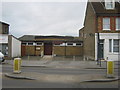
St. Lawrence Parish Hall, Ramsgate
On the A253 High Street.
Image: © David Anstiss
Taken: 6 Feb 2011
0.18 miles
10
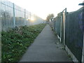
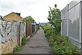
Public footpath alongside the railway, Newington
Behind the houses in Telham Avenue. Once the old footpath to St Lawrence Church crossed the railway on the flat, but at some point it was diverted along here to cross the line on a road bridge.
Image: © Christine Johnstone
Taken: 17 Feb 2022
0.18 miles