IMAGES TAKEN NEAR TO
Windermere Avenue, RAMSGATE, CT11 0PE
Introduction
This page details the photographs taken nearby to Windermere Avenue, CT11 0PE by members of the Geograph project.
The Geograph project started in 2005 with the aim of publishing, organising and preserving representative images for every square kilometre of Great Britain, Ireland and the Isle of Man.

There are currently over 7.5m images from over14,400 individuals and you can help contribute to the project by visiting https://www.geograph.org.uk
Image Map
Images are licensed for reuse under creativecommons.org/licenses/by-sa/2.0
Notes
- Clicking on the map will re-center to the selected point.
- The higher the marker number, the further away the image location is from the centre of the postcode.
Image Listing (10 Images Found)
Images are licensed for reuse under creativecommons.org/licenses/by-sa/2.0
Image
Details
Distance
2
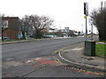
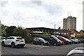
Junction of Princess Margaret Avenue onto the B2050 Manston Road
Image: © Nick Smith
Taken: 12 Jan 2010
0.19 miles
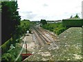
3

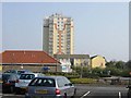
Railway west of Ramsgate station
The station and depot are beyond the next bridge, but closer is the train washer, on the left.
Image: © Robin Webster
Taken: 29 Nov 2016
0.19 miles
4
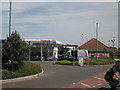
Tesco Manston Petrol Station
Beside the entrance to the store on the B2050 Manston Road.
Image: © David Anstiss
Taken: 23 May 2011
0.21 miles

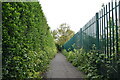
8

Public footpath off Melbourne Avenue, Newington
Fenced off from 'The Copse' on one side and Newington Community Primary School on the other. The schoolchildren designed the artwork. This footpath is shown on the large scale OS map from the 1870s, when it led to St Lawrence's Church.
Image: © Christine Johnstone
Taken: 17 Feb 2022
0.24 miles