IMAGES TAKEN NEAR TO
Joss Gap Road, BROADSTAIRS, CT10 3PG
Introduction
This page details the photographs taken nearby to Joss Gap Road, CT10 3PG by members of the Geograph project.
The Geograph project started in 2005 with the aim of publishing, organising and preserving representative images for every square kilometre of Great Britain, Ireland and the Isle of Man.

There are currently over 7.5m images from over14,400 individuals and you can help contribute to the project by visiting https://www.geograph.org.uk
Image Map
Images are licensed for reuse under creativecommons.org/licenses/by-sa/2.0
Notes
- Clicking on the map will re-center to the selected point.
- The higher the marker number, the further away the image location is from the centre of the postcode.
Image Listing (75 Images Found)
Images are licensed for reuse under creativecommons.org/licenses/by-sa/2.0
Image
Details
Distance
1
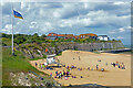
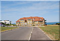
Thanet Coastal Path, Joss Bay
The house ahead is Redcourt on Joss Gap Road, which is parallel with the path, hidden by vegetation on the right.
Image: © Robin Webster
Taken: 23 Nov 2011
0.01 miles
5
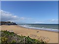
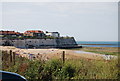
Joss Bay, North Foreland
Looking north across the sandy beach at Joss Bay.
Image: © G Laird
Taken: 14 Sep 2018
0.06 miles
6
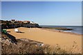
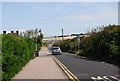
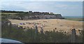
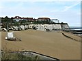
The beach in Joss Bay
Looking towards Hackemdown Point.
Image: © Steve Daniels
Taken: 12 Oct 2012
0.07 miles
7
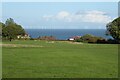
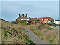
View of wind turbines
View of wind turbines off the east Kent coast at North Foreland.
Image: © Philip Halling
Taken: 20 Oct 2022
0.07 miles