IMAGES TAKEN NEAR TO
The Bungalow, Sacketts Hill, BROADSTAIRS, CT10 2QT
Introduction
This page details the photographs taken nearby to The Bungalow, Sacketts Hill, CT10 2QT by members of the Geograph project.
The Geograph project started in 2005 with the aim of publishing, organising and preserving representative images for every square kilometre of Great Britain, Ireland and the Isle of Man.

There are currently over 7.5m images from over14,400 individuals and you can help contribute to the project by visiting https://www.geograph.org.uk
Image Map
Images are licensed for reuse under creativecommons.org/licenses/by-sa/2.0
Notes
- Clicking on the map will re-center to the selected point.
- The higher the marker number, the further away the image location is from the centre of the postcode.
Image Listing (4 Images Found)
Images are licensed for reuse under creativecommons.org/licenses/by-sa/2.0
Image
Details
Distance
1
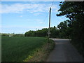
Sackett's Hill
This farm access road leads from the farm to the A255 Dane Court Road.
It is also the final part of a footpath from Sloe Lane.
Image: © David Anstiss
Taken: 8 May 2011
0.10 miles
2
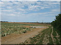
Sloe Lane (track)
This track (and footpath) leads from the A254 Ramsgate towards the A255 Dane Court. It passes a hidden underground water reservoir.
In the background is the suburbs of Cliftonville.
Image: © David Anstiss
Taken: 8 May 2011
0.23 miles
3

Footpath to Westwood Road
This field edge path leads from Dane Court Road, past Buddles Farm.
Image: © David Anstiss
Taken: 20 Feb 2011
0.24 miles
4
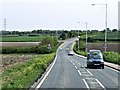
A255, St Peter's Road
The road between Margate and Broadstairs.
Image: © David Dixon
Taken: 16 May 2013
0.25 miles