IMAGES TAKEN NEAR TO
Caernarvon Gardens, BROADSTAIRS, CT10 1AL
Introduction
This page details the photographs taken nearby to Caernarvon Gardens, CT10 1AL by members of the Geograph project.
The Geograph project started in 2005 with the aim of publishing, organising and preserving representative images for every square kilometre of Great Britain, Ireland and the Isle of Man.

There are currently over 7.5m images from over14,400 individuals and you can help contribute to the project by visiting https://www.geograph.org.uk
Image Map
Images are licensed for reuse under creativecommons.org/licenses/by-sa/2.0
Notes
- Clicking on the map will re-center to the selected point.
- The higher the marker number, the further away the image location is from the centre of the postcode.
Image Listing (346 Images Found)
Images are licensed for reuse under creativecommons.org/licenses/by-sa/2.0
Image
Details
Distance
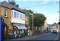
3
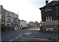
Nelson Place at the corner of Rectory Road
Image: © David Howard
Taken: 30 Jun 2018
0.08 miles
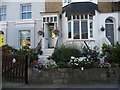
4
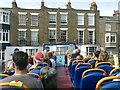
Heading for houses
Open top bus in Broadstairs at Nelson Place. The bus will make a tight turn to the left although it looks to be heading straight into front gardens!
The houses are 21-25 Nelson Place, dating from the early 19th century and Listed Grade II.
Image: © Alan Murray-Rust
Taken: 4 Sep 2022
0.08 miles
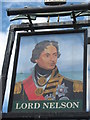
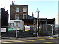
6
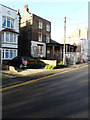
Former Lord Nelson, 11, Nelson Place
The public house closed for the last time on 29 July 2014. David Anstiss Image shows the premises, when it was a thriving public house.
Planning permission under application number F/TH/14/1066 was initially refused by Thanet District Council but was granted (following an appeal) by the planning inspectorate under appeal ref: APP/Z2260/W/15/3016558 for the “change of use from public house to five flats together with 3-storey extension following demolition of the single storey front extension and bar. It is also proposed to demolish the single storey outbuilding to the west of the site”.
Image: © John Baker
Taken: 2 Jan 2017
0.10 miles
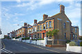
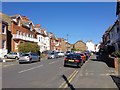
7
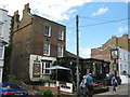
Lord Nelson Public House, Broadstairs
On the junction of Nelson Place (in front) and Devonshire Terrace (behind the pub).
Image: © David Anstiss
Taken: 8 May 2011
0.10 miles
8
Former Lord Nelson, 11, Nelson Place
The public house closed for the last time on 29 July 2014. David Anstiss Image shows the premises, when it was a thriving public house.
Planning permission under application number F/TH/14/1066 was initially refused by Thanet District Council but was granted (following an appeal) by the planning inspectorate under appeal ref: APP/Z2260/W/15/3016558 for the “change of use from public house to five flats together with 3-storey extension following demolition of the single storey front extension and bar. It is also proposed to demolish the single storey outbuilding to the west of the site”.
Image: © John Baker
Taken: 2 Jan 2017
0.10 miles