IMAGES TAKEN NEAR TO
Hastings Road, CROYDON, CR9 6BR
Introduction
This page details the photographs taken nearby to Hastings Road, CR9 6BR by members of the Geograph project.
The Geograph project started in 2005 with the aim of publishing, organising and preserving representative images for every square kilometre of Great Britain, Ireland and the Isle of Man.

There are currently over 7.5m images from over14,400 individuals and you can help contribute to the project by visiting https://www.geograph.org.uk
Image Map
Images are licensed for reuse under creativecommons.org/licenses/by-sa/2.0
Notes
- Clicking on the map will re-center to the selected point.
- The higher the marker number, the further away the image location is from the centre of the postcode.
Image Listing (54 Images Found)
Images are licensed for reuse under creativecommons.org/licenses/by-sa/2.0
Image
Details
Distance
1
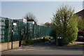
Addiscombe Railway Park
The southern entrance to the park.
Addiscombe Railway Park is a 3.3 acres (1.3 ha) linear park. The first section of the park was opened on 26 May 2007, with the second section opened on 15 March 2010.
It occupies the track route and green buffering land of the demolished 'Addiscombe Line', a short railway that ran between Lower Addiscombe Road and Woodside Junction.
Image: © Peter Trimming
Taken: 11 Apr 2020
0.07 miles
2
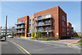
New flats, Grant Road
A redevelopment of a commercial site.
Image: © Robin Webster
Taken: 19 Apr 2019
0.09 miles
3
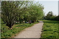
Addiscombe Railway Park
Addiscombe Railway Park is a 3.3 acres (1.3 ha) linear park. The first section of the park was opened on 26 May 2007, with the second section opened on 15 March 2010.
It occupies the track route and green buffering land of the demolished 'Addiscombe Line', a short railway that ran between Lower Addiscombe Road and Woodside Junction.
Image: © Peter Trimming
Taken: 11 Apr 2020
0.09 miles
5

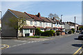
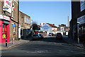
Lower Addiscombe Road, Croydon CR0
Shops being reconverted to dwellings, just east of the railway.
Image: © Philip Talmage
Taken: 8 Sep 2005
0.11 miles
6

The Leslie Arms and Cherry Orchard Road, Croydon CR0
Looking southwest from Addiscombe Road. Despite being closed and shuttered, the Leslie Arms is a grade 2 listed building.
Image: © Philip Talmage
Taken: 8 Sep 2005
0.11 miles
7
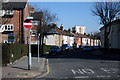
Croydon: Hastings Road
Off the north side of Lower Addiscombe Road
Image: © Dr Neil Clifton
Taken: 5 Mar 2010
0.12 miles
8
Croydon: Warren Road
Off the north side of Lower Addiscombe Road, (A222)
Image: © Dr Neil Clifton
Taken: 5 Mar 2010
0.13 miles
9
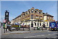
The Alma Tavern, Lower Addiscombe Road (A222)
On the corner of Grant Road.
Image: © Robin Webster
Taken: 19 Apr 2019
0.13 miles
10
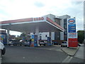
Esso petrol station, Lower Addiscombe Road, Croydon
Image: © Stacey Harris
Taken: 28 Aug 2010
0.13 miles