IMAGES TAKEN NEAR TO
Park Lane, CROYDON, CR9 1JR
Introduction
This page details the photographs taken nearby to Park Lane, CR9 1JR by members of the Geograph project.
The Geograph project started in 2005 with the aim of publishing, organising and preserving representative images for every square kilometre of Great Britain, Ireland and the Isle of Man.

There are currently over 7.5m images from over14,400 individuals and you can help contribute to the project by visiting https://www.geograph.org.uk
Image Map
Images are licensed for reuse under creativecommons.org/licenses/by-sa/2.0
Notes
- Clicking on the map will re-center to the selected point.
- The higher the marker number, the further away the image location is from the centre of the postcode.
Image Listing (627 Images Found)
Images are licensed for reuse under creativecommons.org/licenses/by-sa/2.0
Image
Details
Distance
1
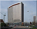
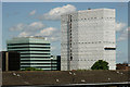
Taberner House, Park Lane (2)
A large slab and podium block designed in-house by H. Thornley in 1964-67, the customer being Croydon Corporation. The slab narrows gradually at both ends so that the middle projects like a shallow arrowhead (also adopted in Portland House: Image]). It is named after Ernest Taberner, Town Clerk, 1937-63. Taberner House currently houses the council's main offices, but is scheduled to be superseded by the building the crane on the left is helping to construct - the indignity of it. See the other side here: Image
Between the 1950s and the 1970s Croydon experienced a burst of commercial development unparalleled anywhere else in the country. The impetus was provided by the Croydon Corporation Act of 1956 which gave Croydon Council powers to develop land in the borough. A combination of improved roads, government incentives to relocate from, and Croydon's proximity to, central London, and lower rents attracted employers in their droves. By 1970 about six million square feet of office space had been provided in central Croydon. Development has continued since, but at a much slower rate. From a distance the skyline is impressive (the nearest this country comes to Manhattan), but the problem is that few of the buildings are of architectural merit.
On the far right is St George's House (Image]).
Image: © Stephen Richards
Taken: 20 Mar 2011
0.01 miles
2
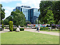
Taberner House, Park Lane (1)
A large slab and podium block designed in-house by H. Thornley in 1964-67, the customer being Croydon Corporation. The slab narrows gradually at both ends so that the middle projects like a shallow arrowhead (also adopted in Portland House: Image]). It is named after Ernest Taberner, Town Clerk, 1937-63. Taberner House currently houses the council's main offices, but work is underway on its replacement. See the other side here: Image
Between the 1950s and the 1970s Croydon experienced a burst of commercial development unparalleled anywhere else in the country. The impetus was provided by the Croydon Corporation Act of 1956 which gave Croydon Council powers to develop land in the borough. A combination of improved roads, government incentives to relocate from, and Croydon's proximity to, central London, and lower rents attracted employers in their droves. By 1970 about six million square feet of office space had been provided in central Croydon. Development has continued since, but at a much slower rate. From a distance the skyline is impressive (the nearest this country comes to Manhattan), but the problem is that few of the buildings are of architectural merit.
In the foreground is Queen's Gardens.
Image: © Stephen Richards
Taken: Unknown
0.01 miles
3
Office blocks on Park Lane, Croydon
Croydon is the nearest thing in Britain to an American city, and had these high rise blocks first after much of the town was bombed in the second world war. London Docklands caught up in the early 21st century but this was the first and still possibly over a wider area.
Image: © David Howard
Taken: 8 Apr 2012
0.01 miles
4
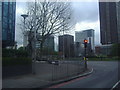
Croydon
Subway at the junction of Croydon Flyover with Park Lane.
Image: © Peter Trimming
Taken: 25 Apr 2020
0.01 miles
5
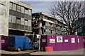
Taberner House
The remains of the former Croydon Council HQ.
Image: © Peter Trimming
Taken: 10 Mar 2015
0.02 miles
6
Taberner House
The remains of the former Croydon Council HQ.
Image: © Peter Trimming
Taken: 10 Mar 2015
0.02 miles
8
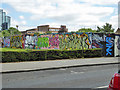
Graffiti wall, Croydon
I believe this is an officially approved feature. It is a pity the artists have not progressed beyond this hackneyed style, which is now rather old-fashioned.
Image: © Robin Webster
Taken: 24 Jul 2016
0.02 miles
9
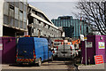
Under Wraps
Looking from Park Hill, a public park. Taberner House is the tower block under wraps and was formerly the headquarters of Croydon Council. It is scheduled to be demolished by the end of 2014.
Image: © Peter Trimming
Taken: 8 Jun 2014
0.03 miles
10
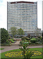
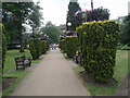
The Queen's Gardens, Croydon
Over to the right is an officially approved graffiti wall.
Image: © Robin Webster
Taken: 24 Jul 2016
0.03 miles