IMAGES TAKEN NEAR TO
Whitgift Centre, CROYDON, CR9 1AT
Introduction
This page details the photographs taken nearby to Whitgift Centre, CR9 1AT by members of the Geograph project.
The Geograph project started in 2005 with the aim of publishing, organising and preserving representative images for every square kilometre of Great Britain, Ireland and the Isle of Man.

There are currently over 7.5m images from over14,400 individuals and you can help contribute to the project by visiting https://www.geograph.org.uk
Image Map
Images are licensed for reuse under creativecommons.org/licenses/by-sa/2.0
Notes
- Clicking on the map will re-center to the selected point.
- The higher the marker number, the further away the image location is from the centre of the postcode.
Image Listing (610 Images Found)
Images are licensed for reuse under creativecommons.org/licenses/by-sa/2.0
Image
Details
Distance
1
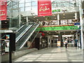
Whitgift Centre
Near the entrance from Wellesley Road
Image: © Paul Gillett
Taken: 22 Jun 2009
0.03 miles
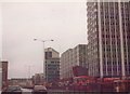
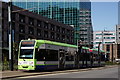
2
Wellesley Road, Croydon
A tram on trial runs southwards along Wellesley Road
Image: © Dr Neil Clifton
Taken: 15 Nov 1999
0.03 miles
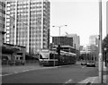
3
Office blocks on Wellesley Road, Croydon 1992
Image: © David Howard
Taken: Unknown
0.03 miles
4
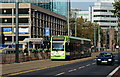
Tram in Wellesley Road, Croydon
A tram for Elmers End, via East Croydon.
Image: © Peter Trimming
Taken: 16 Oct 2011
0.03 miles
5
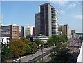
Wellesley Road (1)
Croydon's main artery, and the one which best encapsulates its post-war development. This may evince a snigger or two, but there is a rare thrill about driving down this canyon-like stretch of road.
The prominent central building is Apollo House, built 1967-70 to the designs of Denis Crump & Partners. Like its larger sister, Lunar House (Image]), it houses parts of the UK Border Agency.
Between the 1950s and the 1970s Croydon experienced a burst of commercial development unparalleled anywhere else in the country. The impetus was provided by the Croydon Corporation Act of 1956 which gave Croydon Council powers to develop land in the borough. A combination of improved roads, government incentives to relocate from, and Croydon's proximity to, central London, and lower rents attracted employers in their droves. By 1970 about six million square feet of office space had been provided in central Croydon. Development has continued since, but at a much slower rate. From a distance the skyline is impressive (the nearest this country comes to Manhattan), but the problem is that few of the buildings are of architectural merit.
View in the opposite direction: Image
Image: © Stephen Richards
Taken: 31 Jul 2011
0.03 miles
6
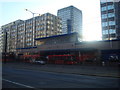
Whitgift Centre, Wellesley Road entrance
Image: © Stacey Harris
Taken: 20 Dec 2009
0.04 miles
7
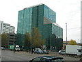
Green Park House, 29 Wellesley Road, Croydon, CR9 2BY
Image: © Danny P Robinson
Taken: 5 Nov 2007
0.04 miles
8
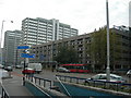
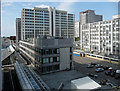
Wellesley Road, Croydon (2)
Taken near junction of Sydenham Road, showing the Whitgift Car Park in the foreground. The subway is the only way to cross the road -- busy traffic and fast moving trams make climbing over the barriers to cross at street level a bad idea. The white concrete blocks to the far left surround Lunar House, a government building that has a strong connection with the enforcement of immigration laws. It is therefore vulnerable to attack and the blocks are intended to prevent vehicles mounting the pavement and being driven into the building.
Image: © Danny P Robinson
Taken: 5 Nov 2007
0.04 miles
10
Whitgift Centre, Wellesley Road
This vast shopping centre, covering eleven acres and the largest in London until the Westfield in 2008, was built in 1965-70, planned by Anthony Minoprio and designed by Fitzroy Robinson & Partners. Above the shops are car parks, a tower (left of shot, Image]), two taller office slabs and a smaller one (on the right), beyond which is Wellesley Road.
Between the 1950s and the 1970s Croydon experienced a burst of commercial development unparalleled anywhere else in the country. The impetus was provided by the Croydon Corporation Act of 1956 which gave Croydon Council powers to develop land in the borough. A combination of improved roads, government incentives to relocate from, and Croydon's proximity to, central London, and lower rents attracted employers in their droves. By 1970 about six million square feet of office space had been provided in central Croydon. Development has continued since, but at a much slower rate. From a distance the skyline is impressive (the nearest this country comes to Manhattan), but the problem is that few of the buildings are of architectural merit.
The taller block in the distance is Lunar House (Image]).
Image: © Stephen Richards
Taken: 31 Jul 2011
0.04 miles