IMAGES TAKEN NEAR TO
Oaks Road, KENLEY, CR8 5NR
Introduction
This page details the photographs taken nearby to Oaks Road, CR8 5NR by members of the Geograph project.
The Geograph project started in 2005 with the aim of publishing, organising and preserving representative images for every square kilometre of Great Britain, Ireland and the Isle of Man.

There are currently over 7.5m images from over14,400 individuals and you can help contribute to the project by visiting https://www.geograph.org.uk
Image Map
Images are licensed for reuse under creativecommons.org/licenses/by-sa/2.0
Notes
- Clicking on the map will re-center to the selected point.
- The higher the marker number, the further away the image location is from the centre of the postcode.
Image Listing (13 Images Found)
Images are licensed for reuse under creativecommons.org/licenses/by-sa/2.0
Image
Details
Distance
1
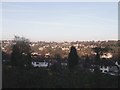
View from Foxley Wood
Overlooking the Riddlesdown Valley.
Image: © David Anstiss
Taken: 13 Nov 2011
0.05 miles
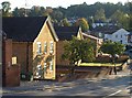
2
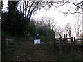
Entrance to Foxley Wood and Higher Drive Recreational Ground
As seen from Burwood Avenue.
Image: © David Anstiss
Taken: 13 Nov 2011
0.07 miles
3
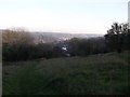
Path in Foxley Wood
This path leads down from Higher Drive Recreational Ground towards Burwood Avenue.
In the background is Kenley in the Riddlesdown Valley. Tunnel Wood is on the other side of the valley.
Image: © David Anstiss
Taken: 13 Nov 2011
0.07 miles
4
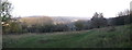
Panorama view from Foxley Wood, Kenley
Looking eastwards across the Riddlestone Valley and the village of Kenley.
In the background is Tunnel Wood.
Image: © David Anstiss
Taken: 13 Nov 2011
0.09 miles
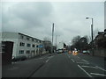
5
Little Roke Road, Kenley
A view from its junction with the A22. On the left are Grafton House and Lucas House.
Image: © Derek Harper
Taken: 15 Oct 2011
0.15 miles
7
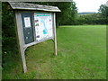
Information about Foxley Wood
In 1867 the Lords of the Manor started selling off plots of land for building development in this area and in 1875 George Armstrong, a prosperous merchant and manufacturer of linseed oil cake, purchased the Great Foxley Estate and built the large house "Foxley", later to be known as Foxley Hall. The estate was again sold in 1893 to Edward Densham, a tea merchant who, with his brothers and father founded the Mazawattee tea company.
The Foxley Estate was finally sold in 1937 to Coulsdon & Purley Urban District Council and is now owned and managed by the London Borough of Croydon. It is situated along the top of the west side of the Caterham Valley. This notice board is on the edge of Higher Drive Recreation Ground and Foxley Wood is to the left. In the distance, Riddlesdown can be seen on the other side of the Caterham Valley - see http://www.geograph.org.uk/photo/3025077
Image: © Marathon
Taken: 18 Jul 2012
0.17 miles
8
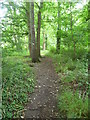
Path in Foxley Wood
In 1867 the Lords of the Manor started selling off plots of land for building development in this area and in 1875 George Armstrong, a prosperous merchant and manufacturer of linseed oil cake, purchased the Great Foxley Estate and built the large house "Foxley", later to be known as Foxley Hall. The estate was again sold in 1893 to Edward Densham, a tea merchant who, with his brothers and father founded the Mazawattee tea company.
The Foxley Estate was finally sold in 1937 to Coulsdon & Purley Urban District Council and is now owned and managed by the London Borough of Croydon. It is situated along the top of the west side of the Caterham Valley. This path runs through a narrow strip of Foxley Wood which lies between Higher Drive Recreation Ground and the gardens of the houses in Densham Drive.
Image: © Marathon
Taken: 18 Jul 2012
0.17 miles
9
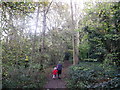
Path in Foxley Wood
A path leads from Woodland Way, Reedham through the woodland nature reserve towards Kenley.
Image: © David Anstiss
Taken: 13 Nov 2011
0.23 miles
10
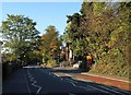
A22 Godstone Road at Kenley
On the right is the junction with St James Road, which is shown in Image Just beyond is Oakwood School.
Image: © Derek Harper
Taken: 15 Oct 2011
0.23 miles