IMAGES TAKEN NEAR TO
Roke Road, KENLEY, CR8 5NQ
Introduction
This page details the photographs taken nearby to Roke Road, CR8 5NQ by members of the Geograph project.
The Geograph project started in 2005 with the aim of publishing, organising and preserving representative images for every square kilometre of Great Britain, Ireland and the Isle of Man.

There are currently over 7.5m images from over14,400 individuals and you can help contribute to the project by visiting https://www.geograph.org.uk
Image Map
Images are licensed for reuse under creativecommons.org/licenses/by-sa/2.0
Notes
- Clicking on the map will re-center to the selected point.
- The higher the marker number, the further away the image location is from the centre of the postcode.
Image Listing (33 Images Found)
Images are licensed for reuse under creativecommons.org/licenses/by-sa/2.0
Image
Details
Distance
1
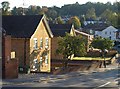
Little Roke Road, Kenley
A view from its junction with the A22. On the left are Grafton House and Lucas House.
Image: © Derek Harper
Taken: 15 Oct 2011
0.11 miles
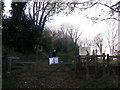
3
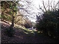
Footpath to Kenley
This track path leads from Fennel Walk down through School House Wood (part of the Riddlesdown to Whyteleafe Countryside Area), leading towards the A22 Godstone Road (in the background).
Image: © David Anstiss
Taken: 13 Nov 2011
0.15 miles
4
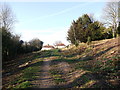
Footpath in School House Wood
This track path leads from the A22 Godstone Road, up through the wood (part of the Riddlesdown to Whyteleafe Countryside Area), leading towards Fennel Walk.
Image: © David Anstiss
Taken: 13 Nov 2011
0.16 miles
5
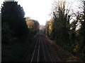
Railway to Purley
This line leads from Oxted (via Warlingham and Whyteleafe) and then Kenley before heading towards Purley and joining the line towards Croydon.
Image: © David Anstiss
Taken: 13 Nov 2011
0.16 miles
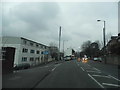
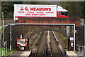
6
Kenley Station
Kenley Railway station. Notice the boarded up station house.
Image: © Hywel Williams
Taken: 22 Sep 2005
0.17 miles
7
Entrance to Foxley Wood and Higher Drive Recreational Ground
As seen from Burwood Avenue.
Image: © David Anstiss
Taken: 13 Nov 2011
0.19 miles
8
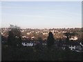
View from Foxley Wood
Overlooking the Riddlesdown Valley.
Image: © David Anstiss
Taken: 13 Nov 2011
0.19 miles
9
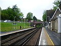
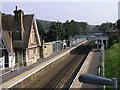
Kenley station
The first proposals for a railway along the Caterham Valley came in 1836 with the object of building a new London to Dover line through a mile long tunnel under the North Downs. It proved too costly and the existing line via Redhill was used. Instead Caterham received a branch line, built by Caterham Railway, a private company, and opened in 1856. The original purpose was to provide a convenient method of transporting the valuable building stone from the quarries at Godstone to London. Soon though the original purpose was overtaken by wealthy Victorian commuters using the line as the Caterham Valley developed. There were early frustrations for these commuters, for example, in the London, Brighton & South Coast Railway arranging for the connecting train at Godstone Road (now Purley) station to leave one minute before the Caterham train arrived. Kenley station opened at the same time as the line but called Coulsdon for four months until December 1856 when it was renamed Kenley. The high-gabled station house on the right dates from the opening of the line and is Grade II listed. It was sold to a private owner in 2007. The booking office is on the up side of the station. This view looks towards Purley.
Image: © Marathon
Taken: 9 May 2012
0.19 miles
10
Bridge at Kenley, Surrey
The bridge takes Hayes Lane over the railway line. Note the different styles of brick which have been used. The yellow bricks, in the arch, appear to be London stock bricks; soot-stained from the era of steam locomotives.
Image: © Peter Trimming
Taken: 1 Apr 2010
0.20 miles