IMAGES TAKEN NEAR TO
Kenley Lane, KENLEY, CR8 5HZ
Introduction
This page details the photographs taken nearby to Kenley Lane, CR8 5HZ by members of the Geograph project.
The Geograph project started in 2005 with the aim of publishing, organising and preserving representative images for every square kilometre of Great Britain, Ireland and the Isle of Man.

There are currently over 7.5m images from over14,400 individuals and you can help contribute to the project by visiting https://www.geograph.org.uk
Image Map
Images are licensed for reuse under creativecommons.org/licenses/by-sa/2.0
Notes
- Clicking on the map will re-center to the selected point.
- The higher the marker number, the further away the image location is from the centre of the postcode.
Image Listing (5 Images Found)
Images are licensed for reuse under creativecommons.org/licenses/by-sa/2.0
Image
Details
Distance
1
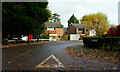
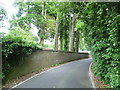
Cumberlands, Kenley, Surrey
Seen from the junction with Kenley Lane.
Image: © Peter Trimming
Taken: 7 Nov 2012
0.10 miles
2
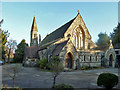
All Saints, Kenley
A Victorian church on a very small site. A church hall (to the right) and car park largely account for the rest of the area, although there is a very tiny garden of remembrance for ashes - the viewpoint. There is no graveyard.
Image: © Robin Webster
Taken: 30 Jan 2011
0.10 miles
3
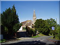
All Saints Church (C of E), Kenley, Surrey
Image: © Dr Neil Clifton
Taken: 24 Sep 2005
0.11 miles
4
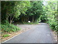
Hayes Lane, Kenley
The sides of the Caterham Valley from Purley to Caterham are quite steep. Hayes Lane leads up from Kenley station to the top of the ridge by Firs Road, but as there are no pavements pedestrians are advised to take the slightly longer route via Park Road. This is the view down Hayes Lane from towards the top of the hill.
Image: © Marathon
Taken: 18 Jul 2012
0.21 miles
5
Hayes Lane, Kenley
The sides of the Caterham Valley from Purley to Caterham are quite steep. Hayes Lane leads up from Kenley station to the top of the ridge by Firs Road, but as there are no pavements pedestrians are advised to take the slightly longer route via Park Road. This is the view down Hayes Lane from near the top of the hill.
Image: © Marathon
Taken: 18 Jul 2012
0.23 miles