IMAGES TAKEN NEAR TO
Frobisher Close, KENLEY, CR8 5HF
Introduction
This page details the photographs taken nearby to Frobisher Close, CR8 5HF by members of the Geograph project.
The Geograph project started in 2005 with the aim of publishing, organising and preserving representative images for every square kilometre of Great Britain, Ireland and the Isle of Man.

There are currently over 7.5m images from over14,400 individuals and you can help contribute to the project by visiting https://www.geograph.org.uk
Image Map
Images are licensed for reuse under creativecommons.org/licenses/by-sa/2.0
Notes
- Clicking on the map will re-center to the selected point.
- The higher the marker number, the further away the image location is from the centre of the postcode.
Image Listing (8 Images Found)
Images are licensed for reuse under creativecommons.org/licenses/by-sa/2.0
Image
Details
Distance
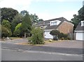
3
Frobisher Close at the junction of Hayes Lane
Image: © David Howard
Taken: 8 Jul 2018
0.04 miles
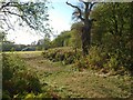
5
Field near Kenley
Crossed by a footpath to Hayes Lane; the trees on the right are in the garden of a house on Hayes Lane.
Image: © Derek Harper
Taken: 15 Oct 2011
0.17 miles
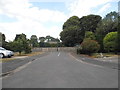
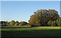
6
Betts Mead Kenley
Betts Mead Kenley looking towards Purley.
Image: © Brett Oliver
Taken: 20 Jun 2007
0.17 miles
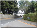
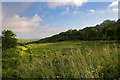
7
Near Kenley
The footpath sign here confused me; it points to the left for the London Loop, which the map told me I'd left behind a hundred metres further southeast. This is from the side of the field shown in Image, looking between the corners of two woods into another field.
Image: © Derek Harper
Taken: 15 Oct 2011
0.19 miles
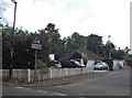
8
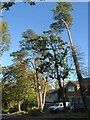
Abbots Lane, Kenley
Some tall pines and other trees along the south side of the residential road.
Image: © Derek Harper
Taken: 15 Oct 2011
0.25 miles