IMAGES TAKEN NEAR TO
Hartley Way, PURLEY, CR8 4EJ
Introduction
This page details the photographs taken nearby to Hartley Way, CR8 4EJ by members of the Geograph project.
The Geograph project started in 2005 with the aim of publishing, organising and preserving representative images for every square kilometre of Great Britain, Ireland and the Isle of Man.

There are currently over 7.5m images from over14,400 individuals and you can help contribute to the project by visiting https://www.geograph.org.uk
Image Map
Images are licensed for reuse under creativecommons.org/licenses/by-sa/2.0
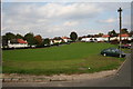
Notes
- Clicking on the map will re-center to the selected point.
- The higher the marker number, the further away the image location is from the centre of the postcode.
Image Listing (31 Images Found)
Images are licensed for reuse under creativecommons.org/licenses/by-sa/2.0
Image
Details
Distance
1
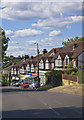
Stoats Nest Parade
The shopping parade at Stoats Nest Road
Image: © Kurseong Carl
Taken: 21 Jul 2010
0.09 miles
2
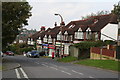
Shops on Stoats Nest Road (2)
Looking downwards from No 85 to 73. No 85 was once a Post Office. Now it is a fish and chip shop...
Image: © Dr Neil Clifton
Taken: 15 Oct 2007
0.10 miles
3
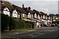
Shops on Stoats Nest Road (1)
This shopping parade put in during the 1930s has seven shops. There were intended to be nine, but the nearest two were each converted into two flats and occupied as such from the start. The shops were originally numbered separately as 'Stoats Nest Parade', consecutively from the furthest one downwards. But now they are numbered upwards as Nos 73 to 85 Stoats Nest Road, with the two that are converted into flats being Nos. 69 (and 69A) and 71 (and 71A).
Image: © Dr Neil Clifton
Taken: 15 Oct 2007
0.10 miles
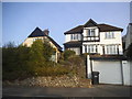
5
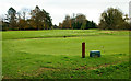
Coulsdon Manor Golf Course, Surrey
Seen from the end of Hartley Old Road.
Image: © Peter Trimming
Taken: 7 Nov 2012
0.12 miles
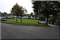
6
Stoats Nest Village, Coulsdon, Surrey (2)
Standing at the north east corner of the green and looking along the exit/entrance road towards Stoats Nest Road. These are some of the ex-Council properties.
Image: © Dr Neil Clifton
Taken: 15 Oct 2007
0.13 miles
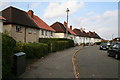
7
Stoats Nest Village (5)
This shows the houses on the north-east side
Image: © Dr Neil Clifton
Taken: 15 Oct 2007
0.15 miles
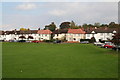
8
Stoats Nest Village (1)
A 1920s/30s development with many of the houses being built by Surrey County Council for Coulsdon and Purley Urban District. The houses, of a variety of types, are tastefully arranged around a green, on which games such as football, etc. are not allowed. Most if not all of the houses are now in private hands.
This photograph is from the north-east end of the green, looking south-west.
Image: © Dr Neil Clifton
Taken: 15 Oct 2007
0.15 miles
9
Stoats Nest Village (6)
This wide view taken from the south-east corner of the green shows the west and north-east sides. Note the way that car parking spaces have been provided so that Cars do not go onto the grass.
Image: © Dr Neil Clifton
Taken: 15 Oct 2007
0.15 miles
10
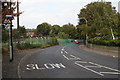
Stoats Nest Road, Coulsdon, Surrey
The part of the road just above the treacherous bend into the railway bridge.
Image: © Dr Neil Clifton
Taken: 15 Oct 2007
0.16 miles