IMAGES TAKEN NEAR TO
Old Lodge Lane, PURLEY, CR8 4AN
Introduction
This page details the photographs taken nearby to Old Lodge Lane, CR8 4AN by members of the Geograph project.
The Geograph project started in 2005 with the aim of publishing, organising and preserving representative images for every square kilometre of Great Britain, Ireland and the Isle of Man.

There are currently over 7.5m images from over14,400 individuals and you can help contribute to the project by visiting https://www.geograph.org.uk
Image Map
Images are licensed for reuse under creativecommons.org/licenses/by-sa/2.0
Notes
- Clicking on the map will re-center to the selected point.
- The higher the marker number, the further away the image location is from the centre of the postcode.
Image Listing (3 Images Found)
Images are licensed for reuse under creativecommons.org/licenses/by-sa/2.0
Image
Details
Distance
1
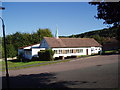
Old Lodge Lane Baptist Church, Purley, Surrey
Image: © Dr Neil Clifton
Taken: 24 Sep 2005
0.10 miles
2
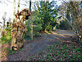
Dead pollard by the crossways
At the end of Firs Road, which is straight ahead, is a footpath crossways. East-west is a path connecting Firs Road with Haydn Avenue, north-south is a path through a long strip of woodland sloping down to the west.
Image: © Robin Webster
Taken: 30 Jan 2011
0.17 miles
3
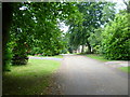
Firs Road, Kenley
It is a pleasure to take photographs along Firs Road because there are hardly any cars parked along here. The size of the driveways makes it completely unnecessary.
Image: © Marathon
Taken: 18 Jul 2012
0.23 miles