IMAGES TAKEN NEAR TO
Woodcote Park Avenue, PURLEY, CR8 3NL
Introduction
This page details the photographs taken nearby to Woodcote Park Avenue, CR8 3NL by members of the Geograph project.
The Geograph project started in 2005 with the aim of publishing, organising and preserving representative images for every square kilometre of Great Britain, Ireland and the Isle of Man.

There are currently over 7.5m images from over14,400 individuals and you can help contribute to the project by visiting https://www.geograph.org.uk
Image Map
Images are licensed for reuse under creativecommons.org/licenses/by-sa/2.0
Notes
- Clicking on the map will re-center to the selected point.
- The higher the marker number, the further away the image location is from the centre of the postcode.
Image Listing (8 Images Found)
Images are licensed for reuse under creativecommons.org/licenses/by-sa/2.0
Image
Details
Distance
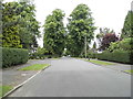
1
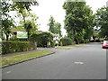
Walburton Road, Woodcote
Purley is accurately described as part of London's stockbroker belt, the roads, houses and views are some of the best this side of the river. It stretches across the North Downs which follow the A23 south past Coulsdon.
Image: © David Howard
Taken: 15 Jun 2014
0.13 miles
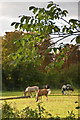
3
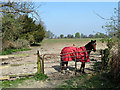
Field with horse
A public footpath to Little Woodcote Lane runs up the left side of the field.
Image: © Robin Webster
Taken: 30 Mar 2012
0.16 miles
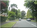
5
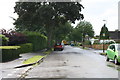
Purley: Verulam Avenue
Looking north.
Image: © Dr Neil Clifton
Taken: 22 Jun 2012
0.17 miles