IMAGES TAKEN NEAR TO
High Street, PURLEY, CR8 2XT
Introduction
This page details the photographs taken nearby to High Street, CR8 2XT by members of the Geograph project.
The Geograph project started in 2005 with the aim of publishing, organising and preserving representative images for every square kilometre of Great Britain, Ireland and the Isle of Man.

There are currently over 7.5m images from over14,400 individuals and you can help contribute to the project by visiting https://www.geograph.org.uk
Image Map
Images are licensed for reuse under creativecommons.org/licenses/by-sa/2.0
Notes
- Clicking on the map will re-center to the selected point.
- The higher the marker number, the further away the image location is from the centre of the postcode.
Image Listing (174 Images Found)
Images are licensed for reuse under creativecommons.org/licenses/by-sa/2.0
Image
Details
Distance
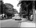
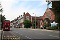
1
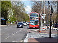
Route 412 bus at Purley
Looking northwards along Brighton Road, Arriva Daf-Wright bus DW 35 is seen taking its layover before returning to West Croydon via the very hilly 412 route via Sanderstead and Selsdon. Said by the drivers to be more powerful than the Dennis Tridents, this type, dating from 2004, is not surprisingly the first choice on the 412.
Image: © Dr Neil Clifton
Taken: 10 Apr 2012
0.01 miles
2
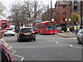
Purley, London Road
The two buses seen in the centre are waiting at the start of their routes. The single decker is on Route 359 which will take it to the Addington interchange via Sanderstead and a diversion to serve Monk's Hill. The double-decker behind is on Route 412, to West Croydon, also via Sanderstead.
Image: © Dr Neil Clifton
Taken: 17 Mar 2017
0.03 miles
3
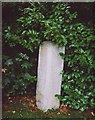
Old Milestone by A235, Purley Memorial Hospital grounds
Carved stone post by the A235, in parish of Purley (Croydon District), grounds of Purley Memorial Hospital, in bushes close to boundary wall, on West side of road. Surrey limestone pillar, erected by the Croydon & Reigate turnpike trust in the 18th century.
Inscription reads:-
: XII / (Miles / from / West / Minster) / Bridge : : XIII / Miles / (from / The / Standard / in) / Cornhill / LONDON / 1743 : : XII / (Miles / from / West) / Minster / Bridge : : 39½ Brighton. :
Greater London HER.
Identifier: MLO101522 https://www.heritagegateway.org.uk/Gateway/Results_Single.aspx?uid=2816320&resourceID=272
Milestone Society National ID: SY_LBT13
Image: © DJ Whines
Taken: 10 Nov 2001
0.03 miles
4
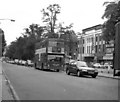
Brighton Road, Purley - 1990
The driver of the DMS bus on Route 59 will be glad he has nearly reached his terminus. Heavy southbound traffic has been a feature here for years.
Image: © Dr Neil Clifton
Taken: 22 Sep 1990
0.03 miles
5
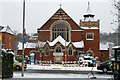
Purley United Reformed Church
Built 1904 as Purley Congregational Church, it is a grade II listed building.
Image: © Robin Webster
Taken: 19 Dec 2010
0.04 miles
6
Brighton Road, Coulsdon: 1981
Here opposite Purley Hospital is seen a Leyland National on Route 414, whose normal western terminus was Horsham, but this bus is on a short working to Reigate.
Image: © Dr Neil Clifton
Taken: 12 Nov 2007
0.04 miles
7
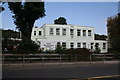
Purley War Memorial Hospital
This small hospital has resisted many attempts at closure. This picture shows the busy Out Patients department.
Image: © Dr Neil Clifton
Taken: 22 Aug 2008
0.04 miles
8
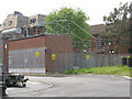
Purley grid substation
A major National Grid substation between Brighton Road and Whytecliffe Road.
Image: © Stephen Craven
Taken: 18 May 2009
0.05 miles
9
Brighton Road, Purley
When Purley was part of the Coulsdon and Purley Urban District, and in Surrey, this road was named quite logically as London Road. But when the area was absorbed by the London Borough of Croydon in 1967, bureaucracy demanded the whole stretch would become known as Brighton Road. The United Reformed Church is seen here on the right, while a bus on Route 412 is at the end of its journey from Croydon via Selsdon.
Image: © Dr Neil Clifton
Taken: 22 Aug 2008
0.05 miles
10
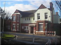
Purley War Memorial Hospital: main entrance
Presumably the original building, which the name suggests would have gone up just after the First World War (when suburban expansion around Purley was intensive).
Image: © Christopher Hilton
Taken: 30 Jan 2011
0.05 miles