IMAGES TAKEN NEAR TO
Edgehill Road, PURLEY, CR8 2ND
Introduction
This page details the photographs taken nearby to Edgehill Road, CR8 2ND by members of the Geograph project.
The Geograph project started in 2005 with the aim of publishing, organising and preserving representative images for every square kilometre of Great Britain, Ireland and the Isle of Man.

There are currently over 7.5m images from over14,400 individuals and you can help contribute to the project by visiting https://www.geograph.org.uk
Image Map
Images are licensed for reuse under creativecommons.org/licenses/by-sa/2.0
Notes
- Clicking on the map will re-center to the selected point.
- The higher the marker number, the further away the image location is from the centre of the postcode.
Image Listing (35 Images Found)
Images are licensed for reuse under creativecommons.org/licenses/by-sa/2.0
Image
Details
Distance
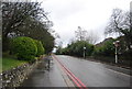
2
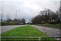
A23 Purley Way
Looking south from the junction with Edgehill Road, just before the end of the dual carriageway.
Image: © Philip Talmage
Taken: 4 Sep 2005
0.05 miles
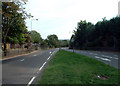
3
Junction of Highfield Close and Purley Way (A23)
Image: © N Chadwick
Taken: 27 Feb 2011
0.07 miles
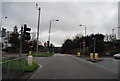
4
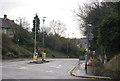
Junction of Edgehill Road and Purley Way
Here Edgehill Road crosses the busy Purley Way (A23). Photograph taken from just west of the junction.
Image: © Peter Trimming
Taken: 17 Mar 2009
0.07 miles
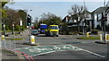
5
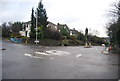
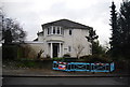
Mini-roundabout, Edgehill Rd and Pampisford Rd
Image: © N Chadwick
Taken: 27 Feb 2011
0.08 miles
10
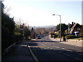
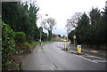
Pampisford Road, Purley
This road leads downhill from South Croydon to central Purley.
Image: © David Anstiss
Taken: 13 Nov 2011
0.11 miles