IMAGES TAKEN NEAR TO
Russell Hill Road, PURLEY, CR8 2LA
Introduction
This page details the photographs taken nearby to Russell Hill Road, CR8 2LA by members of the Geograph project.
The Geograph project started in 2005 with the aim of publishing, organising and preserving representative images for every square kilometre of Great Britain, Ireland and the Isle of Man.

There are currently over 7.5m images from over14,400 individuals and you can help contribute to the project by visiting https://www.geograph.org.uk
Image Map
Images are licensed for reuse under creativecommons.org/licenses/by-sa/2.0
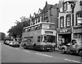
Notes
- Clicking on the map will re-center to the selected point.
- The higher the marker number, the further away the image location is from the centre of the postcode.
Image Listing (164 Images Found)
Images are licensed for reuse under creativecommons.org/licenses/by-sa/2.0
Image
Details
Distance
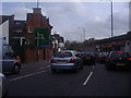
2
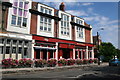
The 'Foxley Hatch', Russell Hill Road, Purley
One of Purley's newer public houses.
Image: © Dr Neil Clifton
Taken: 22 Aug 2008
0.02 miles
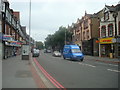
3
The 'Brass Monkey', Russell Hill Road, Purley
Small pub or wine bar, almost opposite the 'Foxley Hatch'. The small single-deck bus is on Route 434, connecting Coulsdon with Whyteleafe and running mostly via back roads which otherwise would not be served.
Image: © Dr Neil Clifton
Taken: 22 Aug 2008
0.02 miles
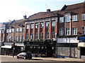
4
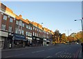
Russell Hill Road, Purley
The shops shown in Image appear here, together with the junction at the top where Purley Way meets Foxley Lane and Pampisford Road. Russell Hill Road, here part of what is in effect a large and busy roundabout, continues up the leafy hill as a quiet residential road.
Image: © Derek Harper
Taken: 15 Oct 2011
0.02 miles
5
The Foxley Hatch, Public House, Purley
On the A23 Purley Way heading into Purley.
Part of the Wetherspoons chain.
Image: © David Anstiss
Taken: 13 Nov 2011
0.03 miles
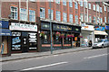
7
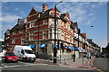
Pizza Express, Purley
Russell Hill Road is to the left, and Brighton Road to the right. Until recently, this building was a bank.
Image: © Dr Neil Clifton
Taken: 22 Aug 2008
0.05 miles
8
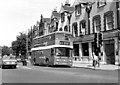
Brighton Road, Purley: 1981
The Atlantean double-decker belonging to London Country is on Route 411, to Reigate. This bus route has now disappeared from the map. The part of Brighton Road shown here does not form a part of the A23, which runs along Purley Way: this older route is now numbered A237.
Image: © Dr Neil Clifton
Taken: 13 Jun 1981
0.05 miles
9
Brighton Road, Purley - 1990
The destination display on this Leyland Olympian of London & Country is not very informative. A passenger requiring Caterham Station would have a long walk if the bus were to terminate at Caterham (Clifton Arms). Interesting is the nearby 'Wimpy' bar - one or two even survive in 2008, in spite of the competition from McDonald's, Burger King, etc.
Image: © Dr Neil Clifton
Taken: 22 Sep 1990
0.05 miles
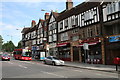
10
The 'Rectory', Brighton Road, Purley
This large new public house advertises itself as a 'Smith and Jones' pub. In my experience, public houses that are part of a chain would be well advised to conceal the fact if possible.
Image: © Dr Neil Clifton
Taken: 22 Aug 2008
0.06 miles