IMAGES TAKEN NEAR TO
More Close, CR8 2GG
Introduction
This page details the photographs taken nearby to More Close, CR8 2GG by members of the Geograph project.
The Geograph project started in 2005 with the aim of publishing, organising and preserving representative images for every square kilometre of Great Britain, Ireland and the Isle of Man.

There are currently over 7.5m images from over14,400 individuals and you can help contribute to the project by visiting https://www.geograph.org.uk
Image Map
Images are licensed for reuse under creativecommons.org/licenses/by-sa/2.0
Notes
- Clicking on the map will re-center to the selected point.
- The higher the marker number, the further away the image location is from the centre of the postcode.
Image Listing (83 Images Found)
Images are licensed for reuse under creativecommons.org/licenses/by-sa/2.0
Image
Details
Distance
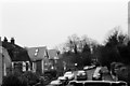
1
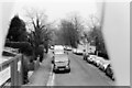
Bird's eye view of Russell Hill
Another view of Russell Hill in Purley, taken from the other end of my lorry from Image Believe it or not, merely walking from one end of my load to another took me into a different grid square! I had to poke the camera between the roof trusses to take this, which is what you can see on either side of the shot. The site I was delivering to is just visible on the left.
Image: © John Winder
Taken: Unknown
0.05 miles
2
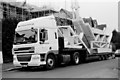
Roof truss delivery
For anyone who is interested, here's a shot of the lorry I stood on to get Image and Image It was a bit of a job to get this to the site, as I recall: the entrance to the road is not obvious and I missed it first time around, and then when I did find it it was so steep that I gouged a groove out of the road surface with the rear corner of the trailer as I took the corner! Still, it all makes for an interesting life, and "the mail must go through", as the song says. All three of these pics were shot on film with my Nikon F3.
Image: © John Winder
Taken: Unknown
0.08 miles
4
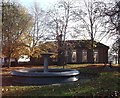
Water fountain, Purley
In front of the Public library, on a green at the junction of Foxley Lane and Banstead Road.
Image: © David Anstiss
Taken: 13 Nov 2011
0.10 miles
5
Russell Hill, Purley
An indifferent photograph, which I felt was worth including as it's taken from an unusual viewpoint: I was standing about fifteen feet off the ground on top of the lorry load of roof trusses I'd just brought down from Hereford! The cab of the lorry is just visible bottom right.
Image: © John Winder
Taken: Unknown
0.11 miles
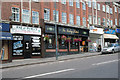
6
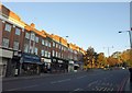
Russell Hill Road, Purley
The shops shown in Image appear here, together with the junction at the top where Purley Way meets Foxley Lane and Pampisford Road. Russell Hill Road, here part of what is in effect a large and busy roundabout, continues up the leafy hill as a quiet residential road.
Image: © Derek Harper
Taken: 15 Oct 2011
0.11 miles
7
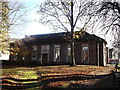
Purley Public Library
On Banstead Road.
Image: © David Anstiss
Taken: 13 Nov 2011
0.11 miles
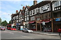
8
The Foxley Hatch, Public House, Purley
On the A23 Purley Way heading into Purley.
Part of the Wetherspoons chain.
Image: © David Anstiss
Taken: 13 Nov 2011
0.12 miles
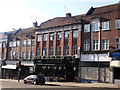
9
The 'Foxley Hatch', Russell Hill Road, Purley
One of Purley's newer public houses.
Image: © Dr Neil Clifton
Taken: 22 Aug 2008
0.12 miles
10
The 'Brass Monkey', Russell Hill Road, Purley
Small pub or wine bar, almost opposite the 'Foxley Hatch'. The small single-deck bus is on Route 434, connecting Coulsdon with Whyteleafe and running mostly via back roads which otherwise would not be served.
Image: © Dr Neil Clifton
Taken: 22 Aug 2008
0.13 miles