IMAGES TAKEN NEAR TO
Whytecliffe Road South, PURLEY, CR8 2FG
Introduction
This page details the photographs taken nearby to Whytecliffe Road South, CR8 2FG by members of the Geograph project.
The Geograph project started in 2005 with the aim of publishing, organising and preserving representative images for every square kilometre of Great Britain, Ireland and the Isle of Man.

There are currently over 7.5m images from over14,400 individuals and you can help contribute to the project by visiting https://www.geograph.org.uk
Image Map
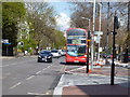
Images are licensed for reuse under creativecommons.org/licenses/by-sa/2.0
Notes
- Clicking on the map will re-center to the selected point.
- The higher the marker number, the further away the image location is from the centre of the postcode.
Image Listing (178 Images Found)
Images are licensed for reuse under creativecommons.org/licenses/by-sa/2.0
Image
Details
Distance
1

Small church, Whytecliffe Road South, Purley
To what exact religion this small church subscribes is not clear from the outside, where a notice merely informs us that 'The Word of God will be preached here on the Lord's Day each week at 7.00 p.m.'
Image: © Dr Neil Clifton
Taken: 22 Aug 2008
0.04 miles
2
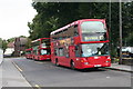
Bus Stand, Whytecliffe Road South, Purley
Route 127 from Tooting Broadway terminates at Purley, and Whytecliffe Road South is used as a stand for buses before they begin the return journey. Here Metrobus Omnidekkers 919 and 920 wait.
Image: © Dr Neil Clifton
Taken: 22 Aug 2008
0.04 miles
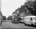
3
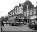
Brighton Road, Purley - 1990
Route 411 which ran from West Croydon to Earlswood (Whitebushes) was one of the long London Country routes which used this road, but many, including the 411, have now disappeared, or been grievously truncated. The bus is opposite the then new Downlands Precint, a small group of shops around a passage that leads through to Purley High Street, and is also a short-cut to the station.
Image: © Dr Neil Clifton
Taken: 22 Sep 1990
0.04 miles
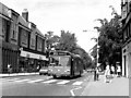
4
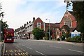
Brighton Road, Purley
When Purley was part of the Coulsdon and Purley Urban District, and in Surrey, this road was named quite logically as London Road. But when the area was absorbed by the London Borough of Croydon in 1967, bureaucracy demanded the whole stretch would become known as Brighton Road. The United Reformed Church is seen here on the right, while a bus on Route 412 is at the end of its journey from Croydon via Selsdon.
Image: © Dr Neil Clifton
Taken: 22 Aug 2008
0.05 miles
5
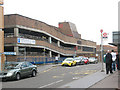
Purley multi-storey car park
The car park is opposite the railway station Image on Whytecliffe Road South.
Image: © Stephen Craven
Taken: 18 May 2009
0.05 miles
6

Purley Leisure Centre
Purley Leisure Centre, the old J Sainsbury building to the left and multi storey car park behind.
Image: © Brett Oliver
Taken: 14 Aug 2009
0.05 miles
7
Route 412 bus at Purley
Looking northwards along Brighton Road, Arriva Daf-Wright bus DW 35 is seen taking its layover before returning to West Croydon via the very hilly 412 route via Sanderstead and Selsdon. Said by the drivers to be more powerful than the Dennis Tridents, this type, dating from 2004, is not surprisingly the first choice on the 412.
Image: © Dr Neil Clifton
Taken: 10 Apr 2012
0.05 miles
8
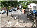
Cycle link on Whytecliffe Road
Whytecliffe Road is now divided into two sections with the suffix 'North' and 'South'. There is no through route for motor traffic but the two are linked by this short cycle path.
Image: © Stephen Craven
Taken: 18 May 2009
0.06 miles
9
Brighton Road, Purley - 1990
Back in 1990, it was quite common to see double deck buses working on the 166. Here we see one, southbound for its Chipstead Valley terminus. Close scrutiny shows that the 'via' blind displayed is incorrect - it's the one intended for the 194.
Image: © Dr Neil Clifton
Taken: 22 Sep 1990
0.06 miles
10
Brighton Road, Purley: 1981
This is part of the A235. The gas showrooms on the left have now completely gone, and many of the Purley shops are now charity shops - a type unknown in 1981. The Leyland National bus on Route 414 is destined for Dorking. This bus route is also merely a memory now.
Image: © Dr Neil Clifton
Taken: 13 Jun 1981
0.06 miles