IMAGES TAKEN NEAR TO
Cross Road, PURLEY, CR8 2DS
Introduction
This page details the photographs taken nearby to Cross Road, CR8 2DS by members of the Geograph project.
The Geograph project started in 2005 with the aim of publishing, organising and preserving representative images for every square kilometre of Great Britain, Ireland and the Isle of Man.

There are currently over 7.5m images from over14,400 individuals and you can help contribute to the project by visiting https://www.geograph.org.uk
Image Map
Images are licensed for reuse under creativecommons.org/licenses/by-sa/2.0
Notes
- Clicking on the map will re-center to the selected point.
- The higher the marker number, the further away the image location is from the centre of the postcode.
Image Listing (19 Images Found)
Images are licensed for reuse under creativecommons.org/licenses/by-sa/2.0
Image
Details
Distance
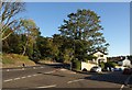
2
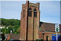
Kenley and Purley Methodist Church
The large church hall is downhill to the left.
Image: © Robin Webster
Taken: 29 May 2011
0.08 miles
3
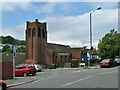
Godstone Tabernacle, Purley
This substantial church was built in 1936 as the Kenley and Purley Methodist Church. It ceased to be a Methodist church in 2012, the last service being held on 25th November. It is now the Godstone Tabernacle according to the somewhat dilapidated red sign outside. See Image for a similar view in 2011.
Image: © Stephen McKay
Taken: 11 Jun 2019
0.08 miles
4
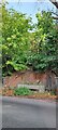
Drinking fountain and water trough, Godstone Road, Purley
Image: © Christopher Hilton
Taken: 3 Oct 2023
0.09 miles
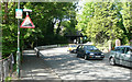
5
Junction, Kenley
The junction of Lower Road (right) with the A22 Godstone Road. On the immediate right is Sylverdale Road; just along the main road is the foot of St James Road - see Image
Image: © Derek Harper
Taken: 15 Oct 2011
0.10 miles
6
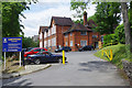
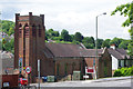
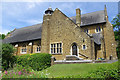
Oakwood School
Oakwood School opened in 1996 and is housed in this Victorian school building. It is an independent school offering education 'with a Catholic ethos' to children aged 3-11.
Image: © Stephen McKay
Taken: 11 Jun 2019
0.10 miles
7
A22 Godstone Road at Kenley
On the right is the junction with St James Road, which is shown in Image Just beyond is Oakwood School.
Image: © Derek Harper
Taken: 15 Oct 2011
0.11 miles
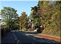
8
St James Road - Steep Hill 14%
St James Road, Riddlesdown. 14% steep hill up sign.
Image: © Adam Morse
Taken: 7 Jun 2009
0.13 miles
9
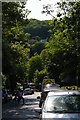
View down St James Road
Across the valley is Foxley Wood.
Taken about 3:30 pm as schools emptied, hence the many parked cars and the parents ferrying children.
Image: © Christopher Hilton
Taken: 11 Jul 2013
0.13 miles
10
St James Church, Parish of Riddlesdown
This Church of England church was established in 1915 and occupies a prominent position on the hillside between Godstone Road and Downs Court Road to the south west of Purley town centre.
Image: © Stephen McKay
Taken: 11 Jun 2019
0.14 miles