IMAGES TAKEN NEAR TO
Hillview Close, PURLEY, CR8 1AU
Introduction
This page details the photographs taken nearby to Hillview Close, CR8 1AU by members of the Geograph project.
The Geograph project started in 2005 with the aim of publishing, organising and preserving representative images for every square kilometre of Great Britain, Ireland and the Isle of Man.

There are currently over 7.5m images from over14,400 individuals and you can help contribute to the project by visiting https://www.geograph.org.uk
Image Map
Images are licensed for reuse under creativecommons.org/licenses/by-sa/2.0
Notes
- Clicking on the map will re-center to the selected point.
- The higher the marker number, the further away the image location is from the centre of the postcode.
Image Listing (94 Images Found)
Images are licensed for reuse under creativecommons.org/licenses/by-sa/2.0
Image
Details
Distance
1
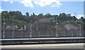
Junction on Warren Road
Warren Road leads up from the A22 Godstone Road towards Riddlesdown Road.
Grasmere Road leads left towards Riddlesdown Road near Purley.
Image: © David Anstiss
Taken: 13 Nov 2011
0.05 miles
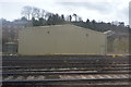
4
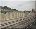
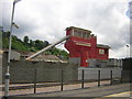
Day Aggregates terminal, Purley
The aggregates terminal is immediately to the east of the main railway line, just north of Purley station. This view is from a passing train. The top of the hopper mechanism (right of picture) is carefully designed to look like a signal box.
Image: © Stephen Craven
Taken: 27 May 2008
0.11 miles
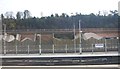
6
Concrete works, next to Purley station
Image: © Christopher Hilton
Taken: 7 Jun 2011
0.13 miles
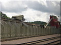
7
Concrete works, next to Purley station
Image: © Christopher Hilton
Taken: 7 Jun 2011
0.13 miles
8
Concrete works, next to Purley station
Image: © Christopher Hilton
Taken: 7 Jun 2011
0.13 miles
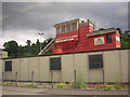
9
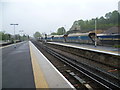
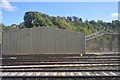
Cement wagons next to Purley station
Purley station was opened by the London & Brighton Railway on 12 July 1841 as Godstone Road. This was closed on 1 October 1847 by the London Brighton & South Coast Railway which had opened the Stoat's Nest station one mile away at Coulsdon. On 5 August 1856 the Caterham branch opened, joining the main line near the site of Godstone Road station. Three months later the LB&SCR reopened its station, this time calling it Caterham Junction. The station was renamed Purley on 1 October 1888 and was rebuilt in 1896 during the widening of the main line between Croydon and Coulsdon. It obtained its name from the Pirelea family who once owned the district. The change followed pressure from the Post Office who complained that mail for Caterham Junction was finishing up at Caterham. This view looks up the line towards East Croydon. A cement works is between the station and the steep cliff next to Warren Road. The lines immediately on the right are for trains on the Caterham and Tattenham Corner branches. Those on the left are for stopping trains. The fast lines are out of sight to the left. The weather was as miserable as it looks.
Image: © Marathon
Taken: 9 May 2012
0.13 miles