IMAGES TAKEN NEAR TO
Zion Place, THORNTON HEATH, CR7 8RR
Introduction
This page details the photographs taken nearby to Zion Place, CR7 8RR by members of the Geograph project.
The Geograph project started in 2005 with the aim of publishing, organising and preserving representative images for every square kilometre of Great Britain, Ireland and the Isle of Man.

There are currently over 7.5m images from over14,400 individuals and you can help contribute to the project by visiting https://www.geograph.org.uk
Image Map
Images are licensed for reuse under creativecommons.org/licenses/by-sa/2.0
Notes
- Clicking on the map will re-center to the selected point.
- The higher the marker number, the further away the image location is from the centre of the postcode.
Image Listing (105 Images Found)
Images are licensed for reuse under creativecommons.org/licenses/by-sa/2.0
Image
Details
Distance
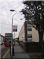
1
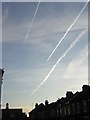
Vapour trails over Zion Place, Thornton Heath, on a cold morning
Flights from southern and south-eastern Europe, and from further destinations that approach from the same direction, approach London Heathrow along this flight-path: emerging from a stack over the North Downs, planes pass over north-westwards over New Addington, swing north-eastwards over Croydon and Thornton Heath and effectively follow the valley of the River Ravensbourne towards the Thames, where they swing west to join the procession of planes (during the daytime, one every 90 seconds) heading west to land at Heathrow.
Image: © Christopher Hilton
Taken: 23 Nov 2011
0.02 miles
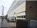
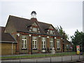
2
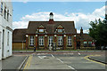
Whitehorse Manor Junior School
Just to the left of the phone box is a small war memorial to former pupils. There is rather more of the school, of newer build, along Whitehorse Road to the left, linking through to the infants school.
Image: © Robin Webster
Taken: 29 Jun 2011
0.03 miles
3
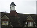
Whitehorse Manor Junior School: detail
On the gable ends, relief sculptures of beehives symbolise industriousness.
Image: © Christopher Hilton
Taken: 12 Sep 2011
0.04 miles
4
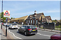
Whitehorse Manor Junior School
The school badge is a rampant white horse, extremely like that of Kent, although this area was never in Kent as far as I can make out.
Image: © Robin Webster
Taken: 19 Apr 2019
0.04 miles
5
Thornton Heath: Strand House, Zion Road
Strand House is Croydon Council's local office. There is a bus stand outside it for routes terminating in Thornton Heath.
Image: © Christopher Hilton
Taken: 21 Oct 2011
0.04 miles
6
Thornton Heath: Strand House, Zion Road
Strand House is Croydon Council's local office.
Image: © Christopher Hilton
Taken: 21 Oct 2011
0.04 miles
7
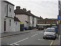
Thornton Heath: Zion Road
Zion Road, a cul-de-sac, ends at a wall beyond which is the main railway line between London and the south coast. A constant stream of trains passes the end of the street. To the left (and given priority by the road markings) the short Zion Place leads through to the main A212 (Whitehorse Road).
Image: © Christopher Hilton
Taken: 21 Oct 2011
0.04 miles
8
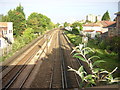
Whitehorse Road, Thornton Heath: view over the railway bridge
Thornton Heath railway station lies beyond the next bridge.
Image: © Christopher Hilton
Taken: 13 Sep 2011
0.05 miles
9
Whitehorse Manor Junior School
In front of the school, a pupil walks past the war memorial commemorating pupils who lost their lives; a poppy wreath is laid in front of it. On the gable ends, relief sculptures of beehives Image symbolise industriousness.
Image: © Christopher Hilton
Taken: 8 Sep 2011
0.05 miles
10
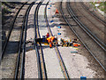
Railway work in progress
The rails appear to be only clipped to the sleepers at wide intervals with some sort of temporary device. The permanent clips appear to be in place but not driven home. The man seems to be using an air drill on something held under his boot, possibly a shim.
Image: © Robin Webster
Taken: 19 Apr 2019
0.06 miles