IMAGES TAKEN NEAR TO
Burlington Road, THORNTON HEATH, CR7 8PH
Introduction
This page details the photographs taken nearby to Burlington Road, CR7 8PH by members of the Geograph project.
The Geograph project started in 2005 with the aim of publishing, organising and preserving representative images for every square kilometre of Great Britain, Ireland and the Isle of Man.

There are currently over 7.5m images from over14,400 individuals and you can help contribute to the project by visiting https://www.geograph.org.uk
Image Map
Images are licensed for reuse under creativecommons.org/licenses/by-sa/2.0
Notes
- Clicking on the map will re-center to the selected point.
- The higher the marker number, the further away the image location is from the centre of the postcode.
Image Listing (77 Images Found)
Images are licensed for reuse under creativecommons.org/licenses/by-sa/2.0
Image
Details
Distance
1
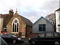
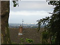
Westbrook Road Evangelical Church
On Westbrook Road.
Image: © David Anstiss
Taken: 18 Dec 2011
0.08 miles
2
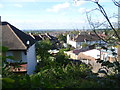
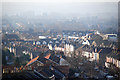
View from Grange Road
There are fine views from the Upper Norwood Ridge around Beulah Hill and Grange Road. This is the view across South London from Grange Road near the junction with Beauchamp Road. The wood on the right in the distance is The Lawns, once the site of Beulah Spa.
Image: © Marathon
Taken: 21 Oct 2011
0.08 miles
3
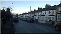
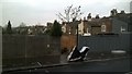
Livingstone Road, Thornton Heath
Image: © Christopher Hilton
Taken: 16 Nov 2016
0.10 miles
4
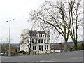
House on Beauchamp Road, Upper Norwood
This house will have an un-obstructed view towards the west. London is on the distant horizon, to the right of picture.
Image: © Peter Trimming
Taken: 28 Feb 2009
0.10 miles
5
Grange Road: view southwest to Sutton
Image: © Christopher Hilton
Taken: 20 Sep 2011
0.10 miles
6
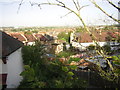
Public footpath between Mersham Road and Livingstone Road, Thornton Heath
This signposted public right of way runs between the backs of gardens on Mersham Road and Livingstone Road. It aligns with a flight of stairs down from Grange Road, crosses Hythe Road at Image and continues on the other side, and is formally designated as a public footpath: all these suggest that it perpetuates a public right of way that predates the houses around it.
Image: © Christopher Hilton
Taken: 7 Dec 2016
0.11 miles
7
Grange Road: view westwards over the streets below
Image: © Christopher Hilton
Taken: 13 Sep 2011
0.11 miles
8
View from Beauchamp Road
There are fine views from the Upper Norwood Ridge around Beulah Hill and Grange Road. This is the view across South London from Beauchamp Road near the junction with Grange Road. The house on the right must have stupendous views.
Image: © Marathon
Taken: 21 Oct 2011
0.12 miles
9
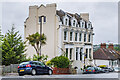
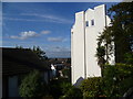
7 & 9 Beauchamp Road
Pair of semi-detached villas marked on the 1896 1:1056 plan, when this road was shown as part of Moffatt (sic) Road.
Image: © Ian Capper
Taken: 6 Jul 2024
0.12 miles
10
view from Grange Road over parts of SE London
Haze / air pollution is quite apparent even at 9/ 10 o'clock on a bright and breezy day
Image: © Chris L L
Taken: 29 Dec 2008
0.12 miles