IMAGES TAKEN NEAR TO
Parchmore Road, THORNTON HEATH, CR7 8HA
Introduction
This page details the photographs taken nearby to Parchmore Road, CR7 8HA by members of the Geograph project.
The Geograph project started in 2005 with the aim of publishing, organising and preserving representative images for every square kilometre of Great Britain, Ireland and the Isle of Man.

There are currently over 7.5m images from over14,400 individuals and you can help contribute to the project by visiting https://www.geograph.org.uk
Image Map (Loading...)


Getting Data...Please wait
Leaflet Map data © OpenStreetMap
Images are licensed for reuse under creativecommons.org/licenses/by-sa/2.0
Notes
- Clicking on the map will re-center to the selected point.
- The higher the marker number, the further away the image location is from the centre of the postcode.
Image Listing (49 Images Found)
Images are licensed for reuse under creativecommons.org/licenses/by-sa/2.0
Image
Details
Distance
5
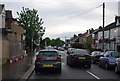
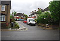
Thornton Heath: Bensham Grove
This provides a link between Northwood Road and Beulah Road
Image: © Dr Neil Clifton
Taken: 19 May 2012
0.11 miles
6
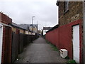
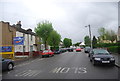
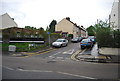
Sandifield Passage, Thornton Heath
This narrow alley leads from Parchmore Road to Bensham Grove.
It is a continuationof Sandifield Road from Melfort Road.
Image: © David Anstiss
Taken: 30 Oct 2011
0.11 miles
7
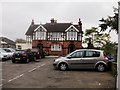
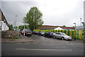
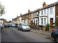
The Fountainhead, Thornton Heath
This former pub is on 114 Parchmore Road. Now converted into flats.
Image: © David Anstiss
Taken: 30 Oct 2011
0.11 miles