IMAGES TAKEN NEAR TO
Colliers Water Lane, THORNTON HEATH, CR7 7LA
Introduction
This page details the photographs taken nearby to Colliers Water Lane, CR7 7LA by members of the Geograph project.
The Geograph project started in 2005 with the aim of publishing, organising and preserving representative images for every square kilometre of Great Britain, Ireland and the Isle of Man.

There are currently over 7.5m images from over14,400 individuals and you can help contribute to the project by visiting https://www.geograph.org.uk
Image Map
Images are licensed for reuse under creativecommons.org/licenses/by-sa/2.0
Notes
- Clicking on the map will re-center to the selected point.
- The higher the marker number, the further away the image location is from the centre of the postcode.
Image Listing (70 Images Found)
Images are licensed for reuse under creativecommons.org/licenses/by-sa/2.0
Image
Details
Distance
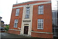
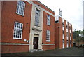
8
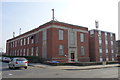
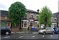
Thornton Heath Telephone Exchange
Stands on the junction of Brigstock Road and Frant Road.
Image: © Peter Trimming
Taken: 20 Mar 2009
0.10 miles
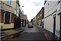
10

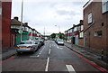
Frant Road, Thornton Heath
Frant Road is a minor road in Thornton Heath, in the suburbs of south London.
Image: © Malc McDonald
Taken: 18 Apr 2022
0.10 miles