IMAGES TAKEN NEAR TO
Jamaica Road, THORNTON HEATH, CR7 7HD
Introduction
This page details the photographs taken nearby to Jamaica Road, CR7 7HD by members of the Geograph project.
The Geograph project started in 2005 with the aim of publishing, organising and preserving representative images for every square kilometre of Great Britain, Ireland and the Isle of Man.

There are currently over 7.5m images from over14,400 individuals and you can help contribute to the project by visiting https://www.geograph.org.uk
Image Map
Images are licensed for reuse under creativecommons.org/licenses/by-sa/2.0
Notes
- Clicking on the map will re-center to the selected point.
- The higher the marker number, the further away the image location is from the centre of the postcode.
Image Listing (61 Images Found)
Images are licensed for reuse under creativecommons.org/licenses/by-sa/2.0
Image
Details
Distance
1
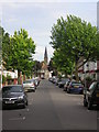
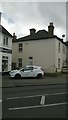
Buxton Road, Thornton Heath
In the distance, the spire of St Saviour's.
Buxton Road is very close to Croydon University Hospital and as a result draconian parking restrictions apply.
Image: © Christopher Hilton
Taken: 16 May 2011
0.06 miles
2
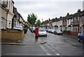
Bensham Lane, Thornton Heath
Bensham Lane is a suburban road in Thornton Heath, south London.
Image: © Malc McDonald
Taken: 18 Apr 2022
0.10 miles
3
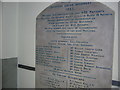
Croydon University Hospital: foundation plaque
Croydon University Hospital (previously the Mayday Hospital) was founded as Croydon Union Infirmary, a Poor Law institution. This foundation plaque is on the ground floor corridor of the original nineteenth-century building, now the Woodcroft Wing.
In the list of ex-officio Guardians, one can see where a name has been cut out above Edmund Byron and replaced by a blank strip of marble. This marks the name of Jabez Balfour, who was a Justice of the Peace and ex-officio Guardian in 1883. He was a non-conformist Liberal politician (for a while, member of Parliament for Tamworth), temperance advocate and founder of a chain of interlocking banks and building societies. In 1892 it was revealed that his Liberator Building Society managed to pay high rates of interest only by paying out capital deposited by more recent customers - in other words, that it was a pyramid or Ponzi scheme - and Balfour fled to Argentina, later returning to serve a period of imprisonment. Clearly after this it was felt that he should be expunged from the historical record and his name cut out of the foundation plaque.
Image: © Christopher Hilton
Taken: 2 Nov 2012
0.10 miles
4
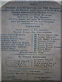
Croydon University Hospital: foundation plaque
Croydon University Hospital (previously the Mayday Hospital) was founded as Croydon Union Infirmary, a Poor Law institution. This foundation plaque is on the ground floor corridor of the original nineteenth-century building, now the Woodcroft Wing.
In the list of ex-officio Guardians, one can see where a name has been cut out above Edmund Byron and replaced by a blank strip of marble. This marks the name of Jabez Balfour, who was a Justice of the Peace and ex-officio Guardian in 1883. He was a non-conformist Liberal politician (for a while, member of Parliament for Tamworth), temperance advocate and founder of a chain of interlocking banks and building societies. In 1892 it was revealed that his Liberator Building Society managed to pay high rates of interest only by paying out capital deposited by more recent customers - in other words, that it was a pyramid or Ponzi scheme - and Balfour fled to Argentina, later returning to serve a period of imprisonment. Clearly after this it was felt that he should be expunged from the historical record and his name cut out of the foundation plaque.
Image: © Christopher Hilton
Taken: 2 Nov 2012
0.10 miles
5
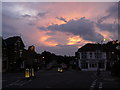
Sunset Over the Junction, Thornton Heath
Sunset over the junction of Bensham Lane with Frant Road and Queen's Road.
Image: © Peter Trimming
Taken: 10 Jul 2009
0.10 miles
7
Terraced house with Ancient Lights sign, Bensham Lane
For more information about Ancient Lights signs, see the information on another image showing such a sign, Image
Bensham Lane cuts across the regular street pattern of nineteenth-century developments (it clearly marks a much older route), resulting in various points like this where houses are staggered rather than forming neat terraces. The area where the car is parked is one such, and would be an attractive space for further development which would block the light to the further house were this right to light not asserted.
Image: © Christopher Hilton
Taken: 27 Apr 2016
0.11 miles
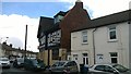
8
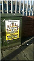
Roots theatre poster, Bensham Lane
Image: © Christopher Hilton
Taken: 5 Jan 2018
0.11 miles
10
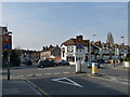
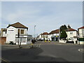
Road Junction in Thornton Heath
Photograph taken from Queen's Road. Frant Road is straight ahead, and the ancient Bensham Lane runs from left to right.
Image: © Peter Trimming
Taken: 20 Mar 2009
0.12 miles