IMAGES TAKEN NEAR TO
Mayday Road, THORNTON HEATH, CR7 7GY
Introduction
This page details the photographs taken nearby to Mayday Road, CR7 7GY by members of the Geograph project.
The Geograph project started in 2005 with the aim of publishing, organising and preserving representative images for every square kilometre of Great Britain, Ireland and the Isle of Man.

There are currently over 7.5m images from over14,400 individuals and you can help contribute to the project by visiting https://www.geograph.org.uk
Image Map
Images are licensed for reuse under creativecommons.org/licenses/by-sa/2.0
Notes
- Clicking on the map will re-center to the selected point.
- The higher the marker number, the further away the image location is from the centre of the postcode.
Image Listing (66 Images Found)
Images are licensed for reuse under creativecommons.org/licenses/by-sa/2.0
Image
Details
Distance
1
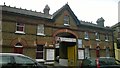
Former coach-house, Mayday Road, Croydon
Now turned, as premises dedicated to horses often did, into a garage.
Image: © Christopher Hilton
Taken: 27 Apr 2016
0.02 miles
2
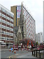
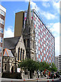
London Road, Croydon
When built, the Church would have been an impressive building. It now looks as if it has been squeezed in between two office blocks. The large block behind the Church is "Fusion", a residential refurbishment of the former Philips headquarters.
Image: © Peter Trimming
Taken: 20 Apr 2009
0.03 miles
3
Oshwal Mahajanwadi Centre
Situated at the junction of Campbell Road and London Road, this building was formerly the Congregational Church of West Croydon.
Image: © Peter Trimming
Taken: 20 Apr 2009
0.04 miles
4
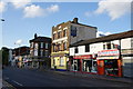
Saints & Sinners
A pub on the corner of Mayday Road.
Image: © Bill Boaden
Taken: 2 Aug 2014
0.04 miles
5
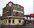
Saints and Sinners, Public House, Broad Green
Public house on the junction of the A235 London Road (in front) and Mayday Road (on the left).
Image: © David Anstiss
Taken: 30 Oct 2011
0.04 miles
6

Dakota House
This used to be a 1960's built office block which in 2007 got converted into "social housing". In the process, it acquired the balconies seen and a much needed facelift.
Image: © Kurseong Carl
Taken: 11 Jun 2011
0.04 miles
7
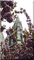
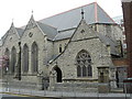
Church Spire
Formerly the Congregational Church at West Croydon, this building is now home to Oshwal Mahajanwadi.
Image: © Peter Trimming
Taken: 20 Apr 2009
0.04 miles
8
West Croydon Congregational Church
Built in 1886, this church has arguably the finest spire in Croydon, whose impact is completely ruined by the rubbish behind it. Come friendly bombs...
Image: © Dr Neil Clifton
Taken: 18 May 2009
0.05 miles
9
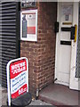
House of Judah, London Road, Broad Green, Croydon
Broad Green is one of the more deprived bits of Croydon. Its religious buildings include Victorian churches still in use, similar churches converted for other religions' use, a mosque, and various Pentecostal-type churches like this meeting in a variety of buildings. This one adjoins the Black and Ethnic Minority Centre.
Image: © Christopher Hilton
Taken: 2 Oct 2010
0.06 miles
10
House of Judah, London Road, Broad Green, Croydon
Broad Green is one of the more deprived bits of Croydon. Its religious buildings include Victorian churches still in use, similar churches converted for other religions' use, a mosque, and various Pentecostal-type churches like this meeting in a variety of buildings. This one adjoins the Black and Ethnic Minority Centre.
Image: © Christopher Hilton
Taken: 2 Oct 2010
0.06 miles