IMAGES TAKEN NEAR TO
Nutfield Road, THORNTON HEATH, CR7 7DP
Introduction
This page details the photographs taken nearby to Nutfield Road, CR7 7DP by members of the Geograph project.
The Geograph project started in 2005 with the aim of publishing, organising and preserving representative images for every square kilometre of Great Britain, Ireland and the Isle of Man.

There are currently over 7.5m images from over14,400 individuals and you can help contribute to the project by visiting https://www.geograph.org.uk
Image Map (Loading...)


Getting Data...Please wait
Leaflet Map data © OpenStreetMap
Images are licensed for reuse under creativecommons.org/licenses/by-sa/2.0
Notes
- Clicking on the map will re-center to the selected point.
- The higher the marker number, the further away the image location is from the centre of the postcode.
Image Listing (39 Images Found)
Images are licensed for reuse under creativecommons.org/licenses/by-sa/2.0
Image
Details
Distance
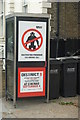
1
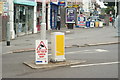
Police Offensive
In an area where burglaries and gun crimes are soaring, the Police have responded with tough measures. Seen at the junction of Colliers Water Lane, and Brigstock Road, Thornton Heath.
Image: © Peter Trimming
Taken: 9 Sep 2009
0.06 miles
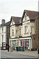
2
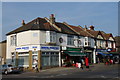
Shops in Brigstock Road
An old parade of shops. 50 years ago, the Dental Practice was Bloomfield (Bakers) and the Food & Wine store was a Greengrocers.
Image: © Peter Trimming
Taken: 20 Mar 2009
0.06 miles
3
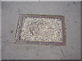
Croydon Corporation tramways duct cover, Brigstock Road, Thornton Heath
Croydon Corporation's tram route no.2 ran from the Greyhound pub in central Croydon to Thornton Heath High Street, via London Road and Brigstock Road. In 1933 the Corporation's trams, along with those of the London County Council and other networks in the capital, were taken over by London Transport, so this duct cover has been in the pavement since the early 1930s at the latest. (Following the takeover, this route became London Transport's route 42.) There is a run of these duct covers all along the north side of Brigstock Road, which is something of a museum of old covers once one starts staring at the pavement whilst walking!
Image: © Christopher Hilton
Taken: 11 Jul 2011
0.07 miles
4
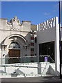
Thornton Heath Library
The Edwardian building and the unloved extension that opened in 2010.
Image: © Christopher Hilton
Taken: 5 Aug 2010
0.09 miles
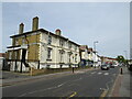
5

The Brigstock Public house
The grid line runs through the middle of the pub. The left hand portion is in this grid square.
Image: © Peter Trimming
Taken: 20 Mar 2009
0.10 miles
6
Thornton Heath Library
The Edwardian building and the unloved extension that opened in 2010.
Image: © Christopher Hilton
Taken: 5 Aug 2010
0.10 miles
7
Aliens in Thornton Heath?
I saw a man, standing outside Thornton Heath library, laughing. This is not normal behaviour, so I returned a few minutes later with my camera. I gather that it's an advertisement for a film, although I have not checked out the website.
Image: © Peter Trimming
Taken: 9 Sep 2009
0.10 miles
8
Brigstock Road, Thornton Heath
Brigstock Road is a suburban 'B' road in Thornton Heath, south London.
Image: © Malc McDonald
Taken: 18 Apr 2022
0.11 miles
9
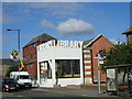
Thornton Heath Library
Whilst the old library is closed for major refurbishment, Thornton Heath library has moved further along Brigstock Road, to this building.
Image: © Peter Trimming
Taken: 9 Sep 2009
0.12 miles
10
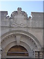
Thornton Heath Library
The main entrance to the Edwardian building, taken during building works in 2010 which improved access to the old building but at the cost of adding a much-disliked modern concrete box entrance to the side of this. The crowning glory of the new entrance is the word "Library" in vast, disproportionate concrete letters. I dislike it so much I'll leave it to someone else to record that part of the building.
Image: © Christopher Hilton
Taken: 17 May 2010
0.13 miles