IMAGES TAKEN NEAR TO
Wharfedale Gardens, THORNTON HEATH, CR7 6LD
Introduction
This page details the photographs taken nearby to Wharfedale Gardens, CR7 6LD by members of the Geograph project.
The Geograph project started in 2005 with the aim of publishing, organising and preserving representative images for every square kilometre of Great Britain, Ireland and the Isle of Man.

There are currently over 7.5m images from over14,400 individuals and you can help contribute to the project by visiting https://www.geograph.org.uk
Image Map
Images are licensed for reuse under creativecommons.org/licenses/by-sa/2.0
Notes
- Clicking on the map will re-center to the selected point.
- The higher the marker number, the further away the image location is from the centre of the postcode.
Image Listing (62 Images Found)
Images are licensed for reuse under creativecommons.org/licenses/by-sa/2.0
Image
Details
Distance
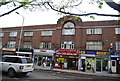
4
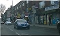
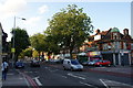
Inter-war row of shops, London Road
Norbury is mostly inter-war suburban development, and this row of shops clearly dates from this era.
Image: © Christopher Hilton
Taken: 16 Jan 2016
0.07 miles
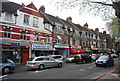
9
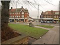
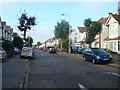
Junction on London Road
The A23 seen from the east end of Pollards Hill South. Across the main road is Kilmartin Avenue.
Image: © Derek Harper
Taken: 13 Jan 2011
0.08 miles