IMAGES TAKEN NEAR TO
Galpins Road, THORNTON HEATH, CR7 6EB
Introduction
This page details the photographs taken nearby to Galpins Road, CR7 6EB by members of the Geograph project.
The Geograph project started in 2005 with the aim of publishing, organising and preserving representative images for every square kilometre of Great Britain, Ireland and the Isle of Man.

There are currently over 7.5m images from over14,400 individuals and you can help contribute to the project by visiting https://www.geograph.org.uk
Image Map
Images are licensed for reuse under creativecommons.org/licenses/by-sa/2.0
Notes
- Clicking on the map will re-center to the selected point.
- The higher the marker number, the further away the image location is from the centre of the postcode.
Image Listing (56 Images Found)
Images are licensed for reuse under creativecommons.org/licenses/by-sa/2.0
Image
Details
Distance
3
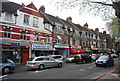
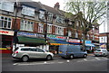
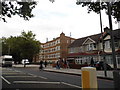
Inter-war row of shops, London Road
Norbury is mostly inter-war suburban development, and this row of shops clearly dates from this era.
Image: © Christopher Hilton
Taken: 16 Jan 2016
0.15 miles
6
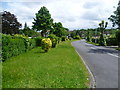
Street scene in Pollards Hill
Pollards Hill occupies the highest point in Norbury and on a clear day the view stretches to Windsor Castle. It was originally part of the Great North Wood and the name 'Pollard' derives from this connection. The road layout of Pollards Hill was shown on maps of 1868 with two avenues of trees. The attractive houses are more recent. This is Pollards Hill West where it bends round by a triangular green to meet Pollards Hill South.
Image: © Marathon
Taken: 6 Jun 2012
0.16 miles
9
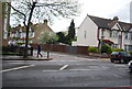
Warwick Gardens, and houses on London Road
The flats are called Warwick Gardens
Image: © David Howard
Taken: 7 Oct 2012
0.16 miles
10
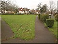
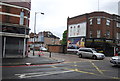
Green, Pollards Hill
A triangular green created among the curving roads of the estate. This view is from the southern corner by Pollards Hill South.
Image: © Derek Harper
Taken: 13 Jan 2011
0.17 miles