IMAGES TAKEN NEAR TO
Hillbury Road, WARLINGHAM, CR6 9TH
Introduction
This page details the photographs taken nearby to Hillbury Road, CR6 9TH by members of the Geograph project.
The Geograph project started in 2005 with the aim of publishing, organising and preserving representative images for every square kilometre of Great Britain, Ireland and the Isle of Man.

There are currently over 7.5m images from over14,400 individuals and you can help contribute to the project by visiting https://www.geograph.org.uk
Image Map
Images are licensed for reuse under creativecommons.org/licenses/by-sa/2.0
Notes
- Clicking on the map will re-center to the selected point.
- The higher the marker number, the further away the image location is from the centre of the postcode.
Image Listing (18 Images Found)
Images are licensed for reuse under creativecommons.org/licenses/by-sa/2.0
Image
Details
Distance
1
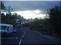
Tithepit Shaw Lane at the junction of Hillbury Road
Image: © David Howard
Taken: 15 Apr 2012
0.09 miles
2
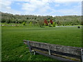
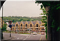
Whyteleafe Recreation Ground
Whyteleafe Recreation Ground is an open space near Warlingham with tennis courts, a children's playground and multi-use open grass space. It is the largest park managed by Tandridge District Council and considered one of the most diverse parks in Surrey, with its open space, woodland, common and grazing land and important south-facing natural chalk grassland.
The path up through the woods can be seen in the centre of the picture which path reaches the top at Tithepit Shaw Lane - see www.geograph.org.uk/photo/7480445
Image: © Marathon
Taken: 4 May 2023
0.13 miles
3
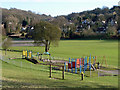
Play area, Whyteleafe recreation ground
A very pleasant place in the afternoon sun, with the steep slopes above grading into natural chalk grassland, scrub and woodland.
Image: © Robin Webster
Taken: 30 Jan 2011
0.16 miles
4
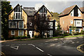
Houses at Whyteleafe
Relatively new houses, on Hillbury Road; B270.
Image: © Peter Trimming
Taken: 20 Oct 2015
0.19 miles
5
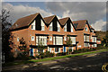
Houses at Whyteleafe
Relatively new houses, on Hillbury Road; B270.
Image: © Peter Trimming
Taken: 20 Oct 2015
0.19 miles
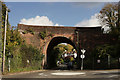
6
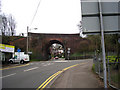
Whyteleafe: Railway bridge over Hillbury Road
The bridge carries the ex-LBSC and SER joint railway from Croydon to Oxted.
Image: © Dr Neil Clifton
Taken: 1 Apr 2011
0.20 miles
7
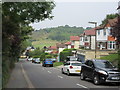
Westhall Road
This long road leads down from Limpsfield Road, through Warlingham.
This is the last short section heading to Hilbury Road.
Whyteleafe Recreational Ground is in the background.
Image: © David Anstiss
Taken: 6 Sep 2014
0.21 miles
8
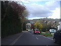
Westhall Road looking towards Hillbury Road
The new houses at the end were built around 2010. The North Downs are behind.
Image: © David Howard
Taken: 15 Apr 2012
0.21 miles
9
Bridge at Whyteleafe
Located just north of Upper Warlingham station, on the line which runs to East Grinstead and Uckfield.
Image: © Peter Trimming
Taken: 20 Oct 2015
0.21 miles
10
The A22 from under the railway bridge on Hillbury Road c1993
A nice view of the North Downs
Image: © David Howard
Taken: Unknown
0.22 miles