IMAGES TAKEN NEAR TO
Westhall Road, WARLINGHAM, CR6 9BJ
Introduction
This page details the photographs taken nearby to Westhall Road, CR6 9BJ by members of the Geograph project.
The Geograph project started in 2005 with the aim of publishing, organising and preserving representative images for every square kilometre of Great Britain, Ireland and the Isle of Man.

There are currently over 7.5m images from over14,400 individuals and you can help contribute to the project by visiting https://www.geograph.org.uk
Image Map
Images are licensed for reuse under creativecommons.org/licenses/by-sa/2.0
Notes
- Clicking on the map will re-center to the selected point.
- The higher the marker number, the further away the image location is from the centre of the postcode.
Image Listing (90 Images Found)
Images are licensed for reuse under creativecommons.org/licenses/by-sa/2.0
Image
Details
Distance
1
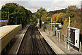
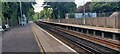
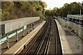
Upper Warlingham Railway Station
Looking in the Croydon (up) direction.
Image: © Peter Trimming
Taken: 20 Oct 2015
0.03 miles
2
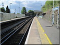
Upper Warlingham railway station, Surrey
Opened in 1884 jointly by the London & Brighton Railway and the South Eastern Railway on what is now the line from Croydon to Uckfield and East Grinstead. View north towards Riddlesdown and Croydon.
Image: © Nigel Thompson
Taken: 16 May 2013
0.03 miles
3
Upper Warlingham station, 2004
View southward, towards Oxted, East Grinstead and Uckfield: ex-LB&SCR & SE&CR Joint (Croydon & Oxted) section of 'Oxted Lines' to Sussex Coast, cut back in the 1960s.
Image: © Ben Brooksbank
Taken: 21 Oct 2004
0.03 miles
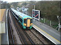
4
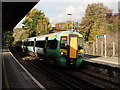
The Train now Arriving
Southern train for East Grinstead, seen arriving at Upper Warlingham.
Image: © Peter Trimming
Taken: 20 Oct 2015
0.03 miles
5
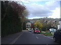
Westhall Road looking towards Hillbury Road
The new houses at the end were built around 2010. The North Downs are behind.
Image: © David Howard
Taken: 15 Apr 2012
0.05 miles
6
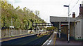
Upper Warlingham Station
View from platform 1
Image: © Bartolo Creations
Taken: 12 Jun 2022
0.06 miles
7
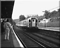
Upper Warlingham station
On the first day of electric services on the East Grinstead line, a '4-CIG' unit is seen on a Down working.
Image: © Dr Neil Clifton
Taken: 27 Sep 1987
0.06 miles
9
Upper Warlingham Railway Station
Looking in the Oxted (down) direction. The line continues to East Grinstead and Uckfield.
Image: © Peter Trimming
Taken: 20 Oct 2015
0.06 miles
10
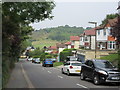
Westhall Road
This long road leads down from Limpsfield Road, through Warlingham.
This is the last short section heading to Hilbury Road.
Whyteleafe Recreational Ground is in the background.
Image: © David Anstiss
Taken: 6 Sep 2014
0.06 miles